Do we need tornado sirens for motivation?

I’ve wondered for a while whether tornado sirens (or, as emergency managers often call them, “outdoor warning sirens”) have become so ingrained in our culture over the past several decades that people instinctively treat them as our most important (if not our only) method to receive warning of impending weather danger.
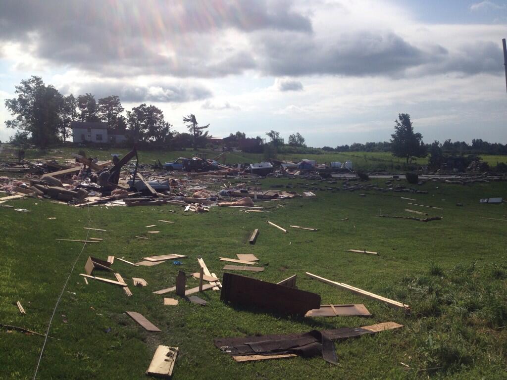
Tornado damage in Smithfield, NY (NWS photo)

Lately, I’ve seen evidence that this is unfortunately the case. It would be unfortunate, because such sirens were never intended to provide warning to people who are indoors and because many, many communities (including the Indiana community in which I live) don’t have enough warning sirens to assure that every person in the community can hear them, even when outdoors.

Why do I think our culture nonetheless puts too much stock in tornado sirens? Here’s one case in point: CBS Evening News reporter Vinita Nair did a report July 9 about a rare New York State tornado that killed four people in the town of Smithfield. In part of her report, Nair said, “Smithfield doesn’t even have tornado sirens.” What prompted that line in her report? I submit that its inclusion indicates how widely-held is the belief that tornado sirens are a primary way to receiving warning of impending danger.

Here’s more evidence to consider. At the 11th International Information Systems for Crisis Response and Management (ISCRAM) Conference in University Park, Pennsylvania, last May, seven authors presented “Tweeting and Tornadoes,” an academic paper that examines the content of geo-located Twitter messages (tweets) sent on the microblog social network during the Moore, Oklahoma tornado of May 20, 2013. Among other findings, the authors noted that the volume of tweets spiked significantly when tornado sirens became audible to Twitter users (see the graph below).
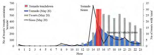
Figure from Blanford, et. al., "Tweeting and Tornadoes"
Figure from Blanford, et. al., “Tweeting and Tornadoes”: Temporal distribution of
tweets with at least one keyword (gray bars) (e.g., ‘storm’, ‘weather’, ‘take/ing cover’, ‘shelter’, ‘pray’, ‘emergency’, ‘red cross’, ‘help’ and ‘devast’, ‘destruct’, and ‘donat’ in relation to tweets containing the keyword ‘tornado’ (blue area) or ‘siren’ (black line) and how these related to the tornado event (red bar). Tweets were summarized for each hour.

The authors write, “Sirens in Moore were sounded six times with the initial siren occurring shortly after the first NWS tornado warning was sent (14:41hr) with the final warning at 15:20hr (Kuligowski et al., 2013). The first mention of sirens also begins at 14:41hr (N=22 tweets in 4 minutes) with tweets such as ‘Sirens going off now!! Take cover…be safe!’, ‘Sirens sirens sirens. Becoming so real’, and ‘If u hear a tornado siren, uve got 6-8 minutes…’”

The tweet that included the words “becoming so real” particularly got my attention. It almost seems as if the writer of that tweet did not begin to appreciate the seriousness of the situation, until she heard sirens. And it came from a person who was obviously connected to the Internet (either via computer or smartphone) and therefore had at her disposal official tweets from NWS and other information sources to enhance situational awareness before sirens sounded.

If, in fact, sirens have become so ingrained in our culture that we need them for motivation when severe weather threatens, I consider that a dangerous trait. Too many of us will never hear a siren, even if a tornado is about to destroy the home we’re in. Even a person who lives close to a siren will likely never hear it just before a non-tornadic severe thunderstorm drops a tree on his house and kills him (because many, if not most, communities don’t sound tornado sirens for severe thunderstorms without imminent tornado threats).

How do we remove tornado sirens from their strongly held homes deep in our collective psyche? Perhaps we can’t. But it sure wouldn’t hurt if trusted news sources and public officials continue to share information with their audiences and constituents about the shortcomings of tornado warning sirens, the necessity of having alternative means of receiving warnings and the importance of reacting immediately and appropriately to those warnings, regardless of whether a tornado siren is audible. Likewise, if you’re reading this blog, chances are good that you’re the severe weather expert in your family, circle of friends, church, etc. You can help to, by spreading the word in your community.

The sound of a tornado siren is so motivating and our response to the sound is so emotional, that the Indianapolis Colts NFL football team uses that sound to rile up the fans during home games at Lucas Oil Stadium. We might never change the emotion associated with that sound. But perhaps we can help protect our communities by doing what we can to build up the importance of other warning methods.

If we’re successful, perhaps someday, the sound of a weather alert radio’s alarm will prompt a tweet like, “Weather radio sounding off. This is becoming so real.”

What do you think? Add your comments to this post (there’s a link right under the title).

Slate article: Why storm chasing has become unethical.

Reed Timmer's "dominator" chase vehicle
Celebrity storm chaser Reed Timmer’s “Dominator” storm chase vehicle during a 2010 chase in Allen County, Ind. (W9LW photo)

Storm chasing has become more controversial lately. Here’s a link to an article on the topic:

Why This Former Storm Chaser Now Thinks Stalking Tornadoes Is Unethical.

Here’s one of the points the author makes:

1) Storm chasers are not saving lives. In fact, storm chasers sometimes put themselves at risk and further burden local emergency managers should they require assistance. Chasers call this phenomenon “chaser convergence,” and it sometimes crowds rural and remote roadways to the point that emergency vehicles can no longer pass.

I think “Slate” author Eric Holthaus over generalizes a bit when he writes, “Storm chasers are not saving lives.”

Some chasers are true scientists who conduct research that might someday save lives by enabling improved forecasts, for example. And some chasers act as both chasers and SKYWARN storm spotters when in the field — in other words, these chasers report the severe weather they see to the nearest National Weather Service office.

Chasers who do bona fide research and those who make reports to the NWS might be saving lives, either in the long term or short term. On the other hand, Holthaus might be correct, if he refers to the remainder of chasers, who neither do true research nor call in reports.

What do you think? Add your comments to this post.

NWS: Winona Lake boy dies in overnight storm

WNDU photo of tree on Winona Lake mobile home
WNDU photo.

See an update to this story: Second storm fatality confirmed.

A 14-year-old Winona Lake boy died early this morning when a large tree fell on a mobile home, according to a preliminary summary of local storm reports issued by the northern Indiana office of the National Weather Service at 8:14 a.m. The NWS attributes the report to Kosciusko County’s emergency management agency, which reported that the fatality occurred at 1:20 a.m.

The NWS had issued a severe thunderstorm warning at 1:02 a.m. for an area that included Winona Lake. The warning was in effect until 1:45 a.m. and included the following language:

* AT 100 AM EDT...SEVERE THUNDERSTORMS WERE LOCATED ALONG A LINE
EXTENDING FROM 6 MILES NORTHEAST OF MENTONE TO 8 MILES SOUTHWEST OF
AKRON...AND MOVING EAST AT 55 MPH.

HAZARD...70 MPH WIND GUSTS.

SOURCE...RADAR INDICATED.

IMPACT...EXPECT CONSIDERABLE TREE DAMAGE. DAMAGE IS LIKELY TO
MOBILE HOMES...ROOFS AND OUTBUILDINGS.

* LOCATIONS IMPACTED INCLUDE...
WARSAW...WINONA LAKE...NORTH MANCHESTER...TRI-LAKES...COLUMBIA
CITY...HUNTINGTON...AKRON...PIERCETON...SOUTH WHITLEY...BURKET...
PALESTINE...BEAVER DAM LAKE...CLUNETTE...GILEAD...MONOQUET...
DISKO...CLAYPOOL...STOCKDALE...SILVER LAKE AND ROANN.

That warning should not have surprised anyone, because all of Kosciusko County had been under severe thunderstorm watch number 381 since 11:35 p.m. Monday night.

As of the time of this writing, the NWS was working with emergency managers throughout its 37-county warning area to determine whether to send out storm survey teams and if so, where to send them.

Below is summary of storm damage reports, issued by the NWS at 8:14 a.m. EDT.

PRELIMINARY LOCAL STORM REPORT...SUMMARY
NATIONAL WEATHER SERVICE NORTHERN INDIANA
814 AM EDT TUE JUL 01 2014

..TIME... ...EVENT... ...CITY LOCATION... ...LAT.LON...
..DATE... ....MAG.... ..COUNTY LOCATION..ST.. ...SOURCE....
..REMARKS..

0900 PM MARINE TSTM WIND 2 WNW POTTAWATTOMIE PAR 41.74N 86.91W
06/30/2014 M49 MPH LMZ046 IN C-MAN STATION

43 KNOTS GUST AT MICHIGAN CITY GLERL STATION

0926 PM TSTM WND GST 5 N LA PORTE 41.68N 86.72W
06/30/2014 E60 MPH LA PORTE IN TRAINED SPOTTER

ESTIMATED WIND GUST OF 50 TO 60 MPH

0926 PM TSTM WND DMG STEVENSVILLE 42.01N 86.52W
06/30/2014 BERRIEN MI PUBLIC

REPORTS OF BRANCHES DOWN

0930 PM MARINE TSTM WIND 4 NW BRIDGMAN 41.98N 86.62W
06/30/2014 M45 MPH LMZ043 MI BUOY

REPORTED BY BUOY WEST OF COOK NUCLEAR PLANT

0930 PM TSTM WND DMG MICHIGAN CITY 41.71N 86.90W
06/30/2014 LA PORTE IN PUBLIC

TWO FOOT DIAMETER TREE SNAPPED AT THE BASE

0936 PM TSTM WND DMG NEW BUFFALO 41.79N 86.74W
06/30/2014 BERRIEN MI AMATEUR RADIO

HANDFUL OF TREES AND POWER LINES DOWN. ALSO DIME SIZE
HAIL

0937 PM HAIL BRIDGMAN 41.94N 86.56W
06/30/2014 E0.75 INCH BERRIEN MI AMATEUR RADIO

0944 PM TSTM WND DMG FISH LAKE 41.57N 86.55W
06/30/2014 LA PORTE IN PUBLIC

DOWNED POWER LINES REPORTED

0950 PM HAIL NEW CARLISLE 41.70N 86.51W
06/30/2014 E1.25 INCH ST. JOSEPH IN PUBLIC

QUARTER TO NEARLY HALF DOLLAR SIZE HAIL.

0955 PM TSTM WND DMG 2 SE DOWAGIAC 41.96N 86.08W
06/30/2014 CASS MI BROADCAST MEDIA

REPORTS OF TREES DOWN BLOCKING SOME STREETS

0955 PM TSTM WND DMG W SOUTH BEND 41.68N 86.25W
06/30/2014 ST. JOSEPH IN 911 CALL CENTER

REPORTS OF TREES AND POWER LINES DOWN ON WEST SIDE OF
SOUTH BEND IN THE EDISON ROAD AREA.

1218 AM TSTM WND GST 5 N LA PORTE 41.68N 86.72W
07/01/2014 E70 MPH LA PORTE IN TRAINED SPOTTER

1218 AM TSTM WND DMG STEVENSVILLE 42.01N 86.52W
07/01/2014 BERRIEN MI PUBLIC

TREE BRANCHES AND POWER LINES DOWN ALONG THE LAKE SHORE
AREAS

1218 AM TSTM WND DMG STEVENSVILLE 42.01N 86.52W
07/01/2014 BERRIEN MI EMERGENCY MNGR

NUMEROUS TREES DOWN UP TO 36 INCHES IN DIAMETER ACROSS
MUCH OF BERRIEN COUNTY.

1222 AM TSTM WND DMG KINGSBURY 41.53N 86.70W
07/01/2014 LA PORTE IN PUBLIC

TREE DOWN ONTO HOME. WINDOWS BROKEN ON WEST SIDE OF
GARAGE. NEAR US 6 AND US 35.

1222 AM TSTM WND DMG KINGSFORD HEIGHTS 41.48N 86.69W
07/01/2014 LA PORTE IN TRAINED SPOTTER

NUMEROUS TREES DOWN ONTO HOMES. SEVERAL ROADS
IMPASSABLE

1230 AM MARINE TSTM WIND 4 NW BRIDGMAN 41.98N 86.62W
07/01/2014 M58 MPH LMZ043 MI BUOY

MEASURED AT BUOY NEAR COOK NUCLEAR PLANT

1230 AM TSTM WND DMG WINAMAC 41.05N 86.60W
07/01/2014 PULASKI IN 911 CALL CENTER

TREES DOWN ACROSS NORTHERN PART OF THE COUNTY
ESPECIALLY NORTH OF WINAMAC

1232 AM TSTM WND GST BUCHANAN 41.83N 86.36W
07/01/2014 M58 MPH BERRIEN MI TRAINED SPOTTER

1237 AM TSTM WND DMG LA PORTE 41.61N 86.72W
07/01/2014 LA PORTE IN PUBLIC

TREE DAMAGE REPORTED AROUND PINE LAKE

1243 AM TSTM WND GST 4 NW SOUTH BEND 41.70N 86.31W
07/01/2014 M68 MPH ST. JOSEPH IN ASOS

1243 AM TSTM WND DMG SOUTH BEND 41.68N 86.25W
07/01/2014 ST. JOSEPH IN AMATEUR RADIO

TREES BLOWN DOWN ALONG GREENLAWN NEAR THE ZOO.

1245 AM TSTM WND DMG SOUTH BEND 41.68N 86.25W
07/01/2014 ST. JOSEPH IN TRAINED SPOTTER

3 TREE LIMBS DOWN AT HOME. ONE LANDED ON CAR

1247 AM TSTM WND DMG LA PAZ 41.46N 86.31W
07/01/2014 MARSHALL IN EMERGENCY MNGR

REPORTS OF MULTIPLE TREES DOWN AS WELL AS POWER LINES
THROUGHOUT THE COUNTY.

1252 AM TSTM WND DMG BREMEN 41.45N 86.15W
07/01/2014 MARSHALL IN PUBLIC

TREES DOWN AND ONE POWER POLE PARTIALLY DOWN IN BREMEN.
TIME ESTIMATED FROM RADAR.

1254 AM TSTM WND DMG TIPPECANOE 41.21N 86.11W
07/01/2014 MARSHALL IN EMERGENCY MNGR

FIRE OFFICIALS REPORTING TREES DOWN

0100 AM TSTM WND GST 2 SE MARCELLUS 42.01N 85.79W
07/01/2014 E75 MPH CASS MI TRAINED SPOTTER

0100 AM TSTM WND GST WAKARUSA 41.54N 86.02W
07/01/2014 M73 MPH ELKHART IN PUBLIC

BETWEEN NAPPANEE AND WAKARUSA WEST OF SR 19. 6 TO 8
INCH DIAMETER LIMBS AND UTILITY LINES DOWN. CORN CROP
LAYED OVER

0108 AM TSTM WND GST ELKHART 41.68N 85.98W
07/01/2014 E60 MPH ELKHART IN PUBLIC

0109 AM TSTM WND GST 4 E LEESBURG 41.33N 85.77W
07/01/2014 E60 MPH KOSCIUSKO IN TRAINED SPOTTER

0110 AM TSTM WND DMG THREE RIVERS 41.94N 85.63W
07/01/2014 ST. JOSEPH MI PUBLIC

TREE DOWN ONTO HOUSE

0110 AM TSTM WND DMG GOSHEN 41.58N 85.83W
07/01/2014 ELKHART IN PUBLIC

TREE DOWN ONTO HOUSE.

0115 AM TSTM WND GST ANGOLA 41.63N 85.00W
07/01/2014 M66 MPH STEUBEN IN AWOS

0119 AM TSTM WND GST 1 E FLOWERFIELD 42.07N 85.64W
07/01/2014 E70 MPH ST. JOSEPH MI TRAINED SPOTTER

0120 AM TSTM WND DMG GRISSOM AFB 40.66N 86.15W
07/01/2014 MIAMI IN EMERGENCY MNGR

REPORTS OF TREES AND POWER LINES DOWN IN EAGLES POINT
NEAR GRISSOM AIR RESERVE BASE

0120 AM TSTM WND DMG WINONA LAKE 41.23N 85.82W
07/01/2014 KOSCIUSKO IN BROADCAST MEDIA

REPORTS OF TREES AND POWER LINES DOWN ACROSS THE
COUNTY. LARGE TREE ONTO SEVERAL TRAILERS IN FAIRLANE
MOBILE HOME PARK.

0120 AM TSTM WND DMG WINONA LAKE 41.23N 85.82W
07/01/2014 KOSCIUSKO IN EMERGENCY MNGR

*** 1 FATAL *** LARGE TREE FELL ON TO MOBILE HOME IN
FAIRLANE MOBILE PARK. EM CONFIRMS 1 FATALITY INSIDE
MOBILE HOME... A 14 YEAR OLD MALE

0121 AM TSTM WND GST GRISSOM AFB 40.66N 86.15W
07/01/2014 M66 MPH MIAMI IN AWOS

0122 AM TSTM WND GST 2 N NORTH WEBSTER 41.36N 85.70W
07/01/2014 E70 MPH KOSCIUSKO IN NWS OFFICE

0123 AM TSTM WND GST TOPEKA 41.54N 85.54W
07/01/2014 E60 MPH LAGRANGE IN TRAINED SPOTTER

0129 AM HAIL KIMMELL 41.40N 85.55W
07/01/2014 E0.75 INCH NOBLE IN TRAINED SPOTTER

0130 AM TSTM WND GST CENTREVILLE 41.92N 85.53W
07/01/2014 E65 MPH ST. JOSEPH MI AMATEUR RADIO

WIND GUSTS AT LEAST 65 MPH.

0130 AM TSTM WND DMG COLUMBIA CITY 41.16N 85.49W
07/01/2014 WHITLEY IN 911 CALL CENTER

TREES... TREE LIMBS AND POWER LINES DOWN THROUGHOUT THE
COUNTY. POWER LINE WAS DOWN ACROSS TRAIN TRACKS NEAR
STATE ROUTES 9 AND 14.

0130 AM TSTM WND DMG ROME CITY 41.50N 85.38W
07/01/2014 NOBLE IN 911 CALL CENTER

TREES AND POWER LINES DOWN THROUGHOUT THE COUNTY.
DAMAGE FOCUS IN ROME CITY.

0135 AM TSTM WND DMG SHERWOOD 42.00N 85.24W
07/01/2014 BRANCH MI EMERGENCY MNGR

NUMEROUS REPORTS OF TREES AND POWER LINES DOWN ACROSS
NORTHERN PART OF THE COUNTY

0136 AM TSTM WND DMG 3 W UNION CITY 42.07N 85.19W
07/01/2014 BRANCH MI EMERGENCY MNGR

POWER LINE DOWN

0152 AM TSTM WND DMG MARKLE 40.82N 85.34W
07/01/2014 HUNTINGTON IN EMERGENCY MNGR

GAS STATION SIGN AND CANAOPY BLOWN OVER I 69 AND US 224

0152 AM TSTM WND DMG ANGOLA 41.63N 85.00W
07/01/2014 STEUBEN IN EMERGENCY MNGR

TREES AND POWER LINES DOWN

0152 AM TSTM WND DMG ANGOLA 41.63N 85.00W
07/01/2014 STEUBEN IN TRAINED SPOTTER

SEVERAL TREES DOWN UP TO 16 INCHES IN DIAMETER ON
MARTHA STREET

0152 AM TSTM WND DMG FORT WAYNE 41.08N 85.13W
07/01/2014 ALLEN IN TRAINED SPOTTER

75 MPH ESTIMATED WIND GUST NEAR NORTHCREST MALL. LARGE
TREE LIMBS DOWN

0152 AM TSTM WND DMG ANGOLA 41.63N 85.00W
07/01/2014 STEUBEN IN EMERGENCY MNGR

NUMEROUS REPORTS OF TREES DOWN INCLUDING ON SOME
HOMES...AS WELL AS POWER LINES. MOST DAMAGE IN THE
ANGOLA AREA.

0155 AM TSTM WND DMG 2 NE NEVADA MILLS 41.74N 85.06W
07/01/2014 STEUBEN IN EMERGENCY MNGR

TREES AND DEBRIS ON US 120 BETWEEN 300 W AND 450 W

0156 AM TSTM WND DMG W ANGOLA 41.63N 85.00W
07/01/2014 STEUBEN IN EMERGENCY MNGR

20 PLUS TREES UPROOTED. FOUR HOMES IN ANGOLA HAVE
SIGNIFICANT DAMAGE.

0156 AM TSTM WND DMG GARRETT 41.35N 85.14W
07/01/2014 DEKALB IN 911 CALL CENTER

SCATTERED REPORTS OF TREES AND POWER LINES DOWN

0156 AM TSTM WND DMG ASHLEY 41.53N 85.07W
07/01/2014 DEKALB IN 911 CALL CENTER

SCATTERED REPORTS OF TREES AND POWER LINES DOWN IN
ASHLEY.

0200 AM TSTM WND GST 3 N FORT WAYNE 41.12N 85.13W
07/01/2014 E65 MPH ALLEN IN TRAINED SPOTTER

TREE LIMBS DOWN WITH ESTIMATED 65 MPH WINDS.

0200 AM TSTM WND DMG 4 N NEW HAVEN 41.13N 85.01W
07/01/2014 ALLEN IN AMATEUR RADIO

SIX INCH LIMBS DOWN ACROSS SR 37 NORTHEAST OF I 469

0201 AM TSTM WND DMG 1 NE NORTH OAKS 40.79N 85.16W
07/01/2014 WELLS IN PUBLIC

TREES DOWN BETWEEN BLUFFTON ADN KINGSLAND. ANOTHER TREE
DOWN BLOCKING ROAD ON 500 N EAST OF SR 1 IN WELLS
COUNTY.

0205 AM TSTM WND DMG 2 W ZULU 41.04N 84.92W
07/01/2014 ALLEN IN PUBLIC

SEMI BLOWN OFF ROAD US 30 NEAR WEBSTER ROAD.

0210 AM TSTM WND DMG HILLSDALE 41.92N 84.63W
07/01/2014 HILLSDALE MI EMERGENCY MNGR

NUMEROUS TREES DOWN ACROSS NORTHERN HALF OF THE COUNTY.

0215 AM TSTM WND DMG JONESVILLE 41.98N 84.66W
07/01/2014 HILLSDALE MI EMERGENCY MNGR

TREES DOWN. SCATTERED POWER OUTAGES

0218 AM TSTM WND GST ANTWERP 41.18N 84.74W
07/01/2014 E70 MPH PAULDING OH PUBLIC

70 MPH WIND GUSTS

0220 AM TSTM WND DMG 4 E MOSCOW 42.05N 84.43W
07/01/2014 HILLSDALE MI TRAINED SPOTTER

TREES DOWN

0230 AM TSTM WND DMG GRISSOM AFB 40.66N 86.15W
07/01/2014 MIAMI IN PUBLIC

2 POWER POLES SNAPPED AT BASE.

0245 AM TSTM WND DMG S OHIO CITY 40.77N 84.62W
07/01/2014 VAN WERT OH EMERGENCY MNGR

LARGE TREE WITH ROT INSIDE SNAPPED HITTING A HOUSE AND
GARAGE ON SOUTH SIDE