Category Archives: SKYWARN

Tornado strikes NW Allen County July 29

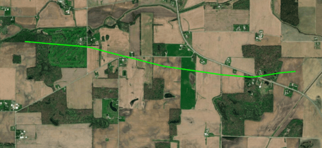
Path of a tornado that touched down just west of the Eel River Golf Course south of Churubusco and tracked rapidly east southeast, crossing US 33 before dissipating in a corn field west of Chase Road. NWS image.

The National Weather Service Northern Indiana weather forecast office (IWX) announced August 2 that it found evidence that a tornado did damage in eastern Whitley County and northwestern Allen County, Indiana at approximately 2:30 a.m. July 29.

“But wait,” you might say, “I never heard about a tornado warning for Allen County that day!” That’s because IWX didn’t issue a tornado warning for this storm. At the time of the tornado, however, a severe thunderstorm warning was in effect that included the words, “tornado possible.”

Most severe thunderstorm warnings do not automatically create alerts on your cell phone.

It’s not unusual for the kind of storm we had Saturday morning (a bowing “squall line”) to spawn weak tornados that appear and disappear before the National Weather Service can issue a warning. That’s why, when they warn us of a severe thunderstorm that could contain such tornados, they mention that a tornado is possible.

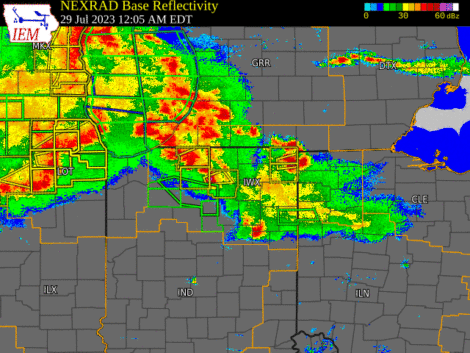
Weather radar loop slowing the bowing squall line that moved across Indiana early July 29.

It’s also one reason that it’s so important to know about and react appropriately to severe thunderstorm warnings, including those the National Weather Service issues in the middle of the night, when you’re sleeping. But that requires extra effort on your part, because most severe thunderstorm warnings do not automatically create alerts on your cell phone.

If you’ve ever been someplace covered by a tornado warning, you probably received a Wireless Emergency Alert (WEA) on your phone, even if you never installed a weather app. That’s because all modern smartphones come with WEAs enabled and all tornado warnings prompt WEAs.

The only severe thunderstorm warnings that trigger WEAs, however, are those in which the National Weather Service includes a “destructive” damage threat “tag.” They do that for storms that have either hail that’s at least 2.75 inches in diameter (baseball-sized) and/or 80 mph straight-line thunderstorm winds. According to Saturday morning’s severe thunderstorm warning, meteorologists expected winds of up to 60 mph and no large hail. That warning therefore did not trigger a WEA.

So, how can you know if a storm like Saturday’s is headed toward your home in the middle of the night, while you’re asleep? I know of two really good ways:

  1. Buy a weather alert radio and keep it near enough to your bedroom to wake you.
  2. Install a weather alert app, like Storm Shield, and configure it to alert you to severe thunderstorm warnings.

When the NWS issues a severe thunderstorm warning for your location, the best way to be safe is to do the same thing you’d do in a tornado warning. Move to the most interior room on the lowest level of your house. This will provide the best protection from a brief tornado, like the one that touched down July 29 and from straight-line thunderstorm winds dropping a tree limb on your house, which is what killed a woman in Ohio City, Ohio July 20.

COVID-19 pandemic affects SKYWARN severe weather operations

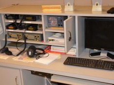
WX9IWX ham radio station at NWS Northern Indiana

Restrictions implemented to slow the spread of COVID-19 will affect one of the ways SKYWARN® storm spotters send reports to local National Weather Service (NWS) offices. Many NWS weather forecast offices (WFOs) have amateur (ham) radio equipment permanently installed. During severe weather events, volunteer ham radio operators operate that equipment to receive reports of tornadoes and other dangerous weather from fellow hams who are storm spotters.

Now, however, the NWS is forbidding anyone not directly connected with the agency from entering WFOs, according to NWS Northern Indiana warning coordination meteorologist Michael Lewis. That means that ham radio stations at WFOs are less likely to be on the air during severe weather events. Some NWS meteorologists have ham radio licenses and some of those might be able to sporadically operate WFO ham stations. But Lewis told me that to reduce exposure to disease, the NWS is trying to operate WFOs with as few people in the office as possible. This might mean that NWS meteorologists who have ham licenses will have no time to operate the ham radio equipment.

Ham radio operators will still be able to use their radios to report severe weather, but they’ll need someone other hams to relay those reports to their local WFOs. That’s where an internal NWS text chat system will be essential, Lewis said. The system is called NWSChat and access is limited a select population. That groups includes ham radio operators who serve as net control station operators. Local ham radio SKYWARN groups can (and should) designate such leaders to serve as liaisons between the radio networks and NWSChat.

Whether or not spotters have ham radio licenses, other ways to communicate reports continue to be available, including telephone calls to WFOs and Twitter tweets that include the appropriate WFO’s Twitter handle.

The voice communication app Zello can also be helpful to SKYWARN storm spotters. Unfortunately, Zello’s terms and conditions do not comply with federal government requirements, so NWS WFOs are prohibited from installing Zello on any government-owned devices. A specific Zello channel exists (“IWX SKYWARN”) for reports from areas covered by the Northern Indiana office. Because WFO staff are prohibited from using Zello, ham radio net control station operators, who have NWSChat accounts, plan to monitor the Zello channel as much as possible, to relay reports from spotters to the WFO.

All this could be tested tomorrow, March 19, when severe weather is forecast in much of Indiana.

Are weather radar apps dangerous?

One well-known meteorologist thinks they can lead untrained users to draw unsafe conclusions

Dr. Kevin Kloesel shows archived radar data from the 2011 Indiana State Fair stage collapse tragedy. The white “X” on his slide indicates the location of the fairgrounds. An outflow boundary (thin, blue line) is depicted ahead of a line of severe thunderstorms.

Anyone who makes decisions based on radar data displayed on mobile apps is essentially “acting the part of a meteorologist without the background,” and that will result in deaths, asserted meteorologist and certified emergency manager Dr. Kevin Kloesel, during the Ohio State University (OSU) Severe Weather Symposium March 28.

Kloesel, who works in the University of Oklahoma Office of Emergency Preparedness, was the final speaker of the day-long symposium, organized by OSU meteorology students.

A non-meteorologist will most likely be using a simple phone app, and tend to focus on the “scary colors” and lowest elevation tilt of the radar, Kloesel told symposium attendees.

As a case in point, Kloesel discussed a 2011 incident at the Indiana State Fair, where winds in advance of a severe thunderstorm caused the collapse of a temporary structure that held spotlights and other equipment above an outdoor concert stage, killing seven people.

Kloesel showed archived radar data from that night, beginning with an 8:35 p.m. scan (see photo above) that depicted a line of heavy precipitation and ahead of that, a thin line representing an outflow boundary. Meteorologists know that such boundaries can indicate gust fronts with strong but usually sub-severe (less than 58 mph) straight-line winds.

Kloesel displays archived radar data from 8:53 p.m. the night of the Indiana State Fair stage collapse. This data shows an outflow boundary apparently right over the fairgrounds, which are represented in Kloesel’s slide by a white “X.”

Archived radar data depict the outflow boundary directly over the fairgrounds at 8:53 p.m (see photo above).

The deadly collapse, however, happened at approximately 8:46 p.m., much earlier than most untrained users of radar data might expect, in part because the “scary colors” had not yet arrived. Even non-meteorologists who recognize outflow boundaries likely don’t know that gust fronts on the ground occur ahead of where outflow boundaries appear on radar.

Kloesel reminds attendees that radar data shows what is happening at the height of the radar beam, which can be quite different than what’s happening directly below that point.

This is because a radar beam rises in reference to the ground as it travels from its source antenna (see photo above). Radar images therefore show what’s happening at the height of the radar beam, not at the ground

Trained meteorologists understand that they cannot assume that what’s happening on the ground will be indicated by what the radar depicts at beam height. Most other users of radar data on mobile apps probably lack that understanding, Kloesel said.

It’s too easy for people to rely on weather data via a mobile app, Kloesel said rather than seek expert consultation. The disconnect between the availability of data and the ability to correctly interpret such data is what led Kloesel to assert that radar app use can be dangerous.

This information is of particular importance to anyone who is responsible for the safety of people attending any outdoor mass gathering. All such events and venues should rely on trained meteorologists, versus others’ interpretations of what they see on mobile apps.

One way event leaders can get such support is through the National Weather Service’s Impact-based Decision Support Services (IDSS). The best way for event organizers to access IDSS is usually through a local emergency manager (i.e. director of an emergency management or homeland security agency).

Kloesel shared a quote from a lawyer involved in a weather-related injury case, who said that such incidents are “preventable with prudent caution and control of events in the face of available meteorological information.”

Demand strong for volunteer storm spotter class

Library expands meeting space to accommodate weather enthusiasts

Strong pre-registrations for a free class on how to recognize and report severe weather phenomena led a local organization to add meeting space to accommodate more people. The Allen County branch of the national Amateur Radio Emergency Service® (ARES) will host the class at the Allen County Public Library, 900 Library Plaza, Fort Wayne, Thursday, Feb. 21 at 6:30 p.m. By Feb. 12, only nine seats were still available, so the library agreed to expand the meeting space, adding 30 seats.

Scheduled speakers include meteorologists from ABC21, Fort Wayne’s NBC, Fox 55 and WANE 15. Allen County Office of Homeland Security director Bernie Beier and Consolidated Communications Partnership deputy director John Chavez also plan to speak.

The class is free and open to the general public, but because fewer than 40 seats are still available, Allen County ARES requests all who plan to attend, to register in advance at https://www.eventbrite.com/e/allen-county-storm-spotter-education-tickets-54685721465

“This two-hour class will provide attendees the knowledge they need to help protect their communities from severe weather like tornadoes,” said Jim Moehring, emergency coordinator (team leader), Allen County ARES. “Although we are a ham radio organization, people need not be hams to be storm spotters, so we welcome anyone who is interested in weather.”

Moehring said the “ground truth” that volunteer spotters provide is essential to the process through which the National Weather Service (NWS) issues storm warnings. He pointed out that this remains true despite advances in weather radar, because the beam from the NWS radar site near North Webster is 2,500 feet or more above the ground by the time it reaches Allen County.

Traditionally, meteorologists from the NWS Northern Indiana office near North Webster have presented spotter training every spring in Fort Wayne. Changes in the office’s responsibilities, however, led it to change its training schedule. As a result, NWS meteorologists won’t be in Fort Wayne until autumn of 2019 and then not again until spring of 2021.

“We wanted to assure that our members and members of the general public have a chance to receive storm spotter education before this spring’s severe weather season,” Moehring said. “We therefore decided to devote our group’s February meeting to a spotter class and to invite everyone to attend. Because NWS meteorologists aren’t available, we’re thrilled that four TV stations in Fort Wayne are sending meteorologists to help teach the weather-related material.”

A complete list of speakers and their topics follows:

  • Jim Moehring, Allen County ARES emergency coordinator (team leader): Introduction to the NWS SKYWARN program and the importance of volunteer storm spotters.
  • Jay Farlow, Allen County ARES assistant emergency coordinator for SKYWARN: How storm warnings are issued and distributed. Also, storm spotter reporting methods and best practices.
  • Charles Ward, experienced storm spotter: Best practices to remain safe while storm spotting.
  • Bernie Beier, Allen County Office of Homeland Security director: The role of the Allen County Office of Homeland Security with regard to severe weather.
  • John Chavez, Consolidated Communications Partnership deputy director: The role of the Consolidated Communication Partnership (911/dispatch) in severe weather events.
  • Caleb Saylor, Fox 55 weekend meteorologist: Thunderstorm basics, including how storms form and become severe.
  • Caleb Chevalier, ABC21 weekend morning meteorologist: Types of thunderstorms, including those most likely to create tornadoes. Also, radar apps and interpretation.
  • Jon Wilson, Fort Wayne’s NBC weekend meteorologist: Thunderstorm hazards, including straight-line winds, large hail, flash flooding and tornadoes.
  • Nicholas Ferreri, WANE 15 chief meteorologist: Cloud identification, including distinguishing scary-looking but benign weather from true threats that spotters should report.

About the Amateur Radio Emergency Service

The Amateur Radio Emergency Service® (ARES) is a program of ARRL, the national association for amateur radio®. ARES establishes teams of volunteer, licensed amateur (ham) radio operators in counties throughout the country, each of which is led by an emergency coordinator. These volunteer teams train and practice to provide communication services to their communities in the event of a disaster. Through a memorandum of understanding signed by ARRL and the National Weather Service (NWS), ARES volunteers also commit to communicating weather information that assists the NWS in the creation of weather warnings. In addition, ARES volunteers practice their communication skills by providing two-way radio communications at public events, such as marathons, walk-a-thons, etc. More information about ARES is available on the ARRL website at http://www.arrl.org/ares.

Fort Wayne organization to host class for volunteer storm spotters

Speakers to include meteorologists from four TV stations

Collaborating for public safety: Meteorologists from four competing Fort Wayne TV stations meet with ARES leaders to help plan storm spotter education. Counterclockwise from lower left: Jim Moehring, KB9WWM, ARES emergency coordinator; Caleb Saylor Fox 55 Weekend Meteorologist; Nicholas Ferreri, WANE 15 Chief Meteorologist; Jon Wilson, Fort Wayne's NBC Weekend Meteorologist; Caleb Chevalier, ABC21 Weekend Morning Meteorologist. Photo by Jay Farlow, ARES Assistant Emergency Coordinator
Collaborating for public safety: Meteorologists from four competing Fort Wayne TV stations meet with ARES leaders to help plan storm spotter education. Counterclockwise from lower left: Jim Moehring, ARES emergency coordinator; Caleb Saylor, Fox 55 Weekend Meteorologist; Nicholas Ferreri, WANE 15 Chief Meteorologist; Jon Wilson, Fort Wayne’s NBC Weekend Meteorologist; Caleb Chevalier, ABC21 Weekend Morning Meteorologist. Photo by Jay Farlow, ARES Assistant Emergency Coordinator

Jan. 25, 2019 – Fort Wayne – A local organization invites anyone who is interested in weather to attend a free class on how to recognize and report severe weather phenomena to benefit public safety. The Allen County branch of the national Amateur Radio Emergency Service® (ACARES) will host the class at the Allen County Public Library, 900 Library Plaza, Fort Wayne, Thursday, Feb. 21 at 6:30 p.m. Scheduled speakers include meteorologists from ABC21, Fort Wayne’s NBC, Fox 55 and WANE 15. Allen County Office of Homeland Security director Bernie Beier and Consolidated Communications Partnership deputy director John Chavez also plan to speak.

The class is free and open to the general public, but seating is limited. ACARES therefore requests all who plan to attend, to register in advance at https://www.eventbrite.com/e/allen-county-storm-spotter-education-tickets-54685721465

“This two-hour class will provide attendees the knowledge they need to help protect their communities from severe weather like tornadoes,” said Jim Moehring, emergency coordinator (team leader), ACARES. “Although we are a ham radio organization, people need not be hams to be storm spotters, so we welcome anyone who is interested in weather.”

Moehring said the “ground truth” that volunteer spotters provide is essential to the process through which the National Weather Service (NWS) issues storm warnings. He pointed out that this remains true despite advances in weather radar, because the beam from the NWS radar site near North Webster is 2,500 feet or more above the ground by the time it reaches Allen County.

Traditionally, meteorologists from the NWS Northern Indiana office near North Webster have presented spotter training every spring in Fort Wayne. Changes in the office’s responsibilities, however, led it to change its training schedule. As a result, NWS meteorologists won’t be in Fort Wayne until autumn of 2019 and then not again until spring of 2021.

“We wanted to assure that our members, and members of the general public have a chance to receive storm spotter education before this spring’s severe weather season,” Moehring said. “We therefore decided to devote our February meeting to a spotter class and to invite everyone to attend. Because NWS meteorologists aren’t available, we’re thrilled that four TV stations in Fort Wayne are sending meteorologists to help teach the weather-related material.”

A complete list of speakers and their topics follows:

  • Jim Moehring, Allen County ARES emergency coordinator (team leader): Introduction to the NWS SKYWARN program and the importance of volunteer storm spotters.
  • Jay Farlow, ACARES assistant emergency coordinator for SKYWARN: How storm warnings are issued and distributed. Also, storm spotter reporting methods and best practices.
  • Charles Ward, experienced storm spotter: Best practices to remain safe while storm spotting.
  • Bernie Beier, Allen County Office of Homeland Security director: The role of the Allen County Office of Homeland Security with regard to severe weather.
  • John Chavez, Consolidated Communications Partnership deputy director: The role of the Consolidated Communication Partnership (911/dispatch) in severe weather events.
  • Caleb Saylor, Fox 55 weekend meteorologist: Thunderstorm basics, including how storms form and become severe.
  • Caleb Chevalier, ABC21 weekend morning meteorologist: Types of thunderstorms, including those most likely to create tornadoes. Also, radar apps and interpretation
  • Jon Wilson, Fort Wayne’s NBC weekend meteorologist: Thunderstorm hazards, including straight-line winds, large hail, flash flooding and tornadoes.
  • Nicholas Ferreri, WANE 15 chief meteorologist: Cloud identification, including distinguishing scary-looking but benign weather from true threats that spotters should report.

About the Amateur Radio Emergency Service

The Amateur Radio Emergency Service® (ARES) is a program of ARRL, the national association for amateur radio®. ARES establishes teams of volunteer, licensed amateur (ham) radio operators in counties throughout the country, each of which is led by an emergency coordinator. These volunteer teams train and practice to provide communication services to their communities in the event of a disaster. Through a memorandum of understanding signed by ARRL and the National Weather Service (NWS), ARES volunteers also commit to communicating weather information that assists the NWS in the creation of weather warnings. In addition, ARES volunteers practice their communication skills by providing two-way radio communications at public events, such as marathons, walk-a-thons, etc. More information about ARES is available on the ARRL website at http://www.arrl.org/ares.

Media Contact

Jay Farlow, volunteer public information officer, ARRL
arsw9lw@gmail.com

WeatherBrains podcast features amateur radio’s role in the weather enterprise

This blog’s author, Jay Farlow, W9LW, joining the WeatherBrains podcast Jan. 7, 2019, via Google Hangouts from his office/radio shack at home in Fort Wayne, Indiana.

A popular, weather-related podcast recently recorded an episode devoted to the role of amateur (ham) radio in the weather enterprise, especially storm spotting. WeatherBrains is a long-running, well-respected podcast hosted by Alabama broadcast meteorologist James Spann. It recorded the ham radio podcast January 7.

Ham radio has been deeply involved in the National Weather Service’s (NWS) SKYWARN® program since its inception, according to research done by Brian E. Smith, the warning coordination meteorologist at the NWS Omaha/Valley weather forecast office (WFO) in Nebraska. During the infamous Palm Sunday tornado outbreak of 1965, a tornado did F4 damage in northern Toledo, Ohio. Afterward, a ham who was also a meteorologist in the Toledo office of what was then called the U.S. Weather Bureau — Merle Kachenmeister, WA8EWW — organized ham radio operators in his area to report severe weather to the Toledo office via radio. This is considered the birth of the SKYWARN program, according to Smith.

WeatherBrains episode number 677 is available for viewing or listening on the the podcast’s website. Listeners can also access the audio-only version on their mobile devices via their favorite podcast apps.

The author of this blog was one of the guests who WeatherBrains invited to discuss ham radio. Other guests included Jeff Stapel, W8SWX of the Muskegon, Michigan SKYWARN organization and Rob Macedo, KD1CY, who is both the Section Emergency Coordinator of the ARRL Eastern Massachusetts section and director of operations for the VOIP Hurricane Net.

During the show, I mentioned several resources that might be valuable to audience members. For your convenience, I’ve listed them below:

  • ARRL, the national association for amateur radio®: This website contains a wealth of information about amateur radio, what hams do, and how to become a licensed ham radio operator.
  • The tornado outbreak of Aug. 24, 2016: This page on the website of the NWS northern Indiana WFO includes the radar rotation tracks I showed during the podcast, as well as other information about how the outbreak affected my home area.
  • ARRL Ham Radio License Manual: This book contains all the information you need to pass the exam and get your ham radio license, so you can join other storm spotters on the air.
  • Storm Spotting and Amateur Radio: This book is a valuable resource for anyone who is interested in either storm spotting or how to use ham radio while spotting. It includes information on resources, training, equipment, safety, storm spotter activation procedures and more.
  • Allen County (Ind.) SKYWARN Net Operations Manual: This PDF document discusses in great detail how the hams of the Fort Wayne and Allen County, Indiana area organize their SKYWARN net — i.e. on-air conference call — during severe weather events.

A couple resources I didn’t have time to get into regard equipment (although Rob mentioned some price ranges). Below are links to some equipment options you might consider, if you’re thinking about getting into ham radio:

  • Baofeng UV-5R handheld radio: Available on Amazon for only $25, this will get you on the air. Like any handheld radio, its geographical range is limited, but as long as you’re close enough to what hams call a “repeater” station, you can talk to people dozens of miles away.
  • AnyTone AT-778UV Mobile radio: Available on Amazon for $130, this radio mounts in your vehicle and connects to your vehicle’s 12-volt poser source. It transmits with 25 watts, versus the 5 watts of most handheld radios, enabling you to communicate while farther from the repeater station. It requires an external antenna, sold separately. Antenna options include those with temporary magnetic mounts and those that can mount more permanently on a trunk lid without drilling holes.

The “big three” brands of ham radio equipment are Icom, Kenwood and Yaesu. Their radios, while well respected, tend to be priced higher on the new market than the Chinese brands above. Note, however, that there’s a large market for pre-owned radios. These can be obtained through some dealers (who take trade-ins), at ham radio flea markets and through online auction sites.

Allen County Group to Host Spotter Training

Anyone can help protect their community from weather threats like tornadoes. In just a couple of hours, you can learn how severe weather forms, how to distinguish truly threatening weather from scary-looking but harmless clouds, and how to report severe weather so the rest of your community can be adequately warned.

The Allen County chapter of the Amateur Radio Emergency Service (ARES) invites all interested persons to attend its Feb. 21 meeting, from 6:30 to 8:30 p.m., at the main, downtown branch of the Allen County Public Library, The meeting will be devoted to severe weather and storm spotting. You don’t have to be a ham radio operator and you don’t need any prior knowledge of meteorology or communications.

Scheduled speakers include ABC21 Weekend Morning Meteorologist Caleb Chevalier, WANE 15 Chief Meteorologist Nicholas Ferreri, FOX 55 weekend Meteorologist Caleb Saylor, Fort Wayne’s NBC Weekend Meteorologist Jon Wilson, Allen County Office of Homeland Security director Bernie Beier, Consolidated Communications Partnership (911/public safety dispatch) director David Bubb, Allen County ARES team leader Jim Moehring and Allen County SKYWARN ham radio net manager Jay Farlow.

Although representatives of the National Weather Service (NWS) are not available for this meeting, we will follow the NWS SKYWARN curriculum with enhancements specific to Allen County. NWS does not plan to teach a spotter class in Allen County until autumn of 2019.

This event is free and only about 100 seats are available. If you plan to come, please register at https://www.eventbrite.com/e/allen-county-storm-spotter-education-tickets-54685721465, so ARES will know if registrations approach the room’s capacity.

This meeting will be valuable to anyone who is interested in severe weather, including those who have previously received storm spotter training. More information is available on the host’s Facebook page.

Info resources for SKYWARN storm spotters

Tonight, I was the guest speaker at a meeting of the Allen County Amateur Radio Technical Society on the topic in the title above. I promised the members present that they would not have to write down all the web URL’s I mentioned, because i’d post them here. Each item in the bulleted list below links directly to the respective online resource.

I’m a storm spotter, not a storm chaser!

Well-known tornado researcher Dr. Chuck Doswell

I can’t count the number of times I’ve gone out of my way to make sure people know I’m not a storm chaser. I’ll very likely stop doing that, however, in part because of something I heard renowned tornado researcher Dr. Chuck Doswell say this week on a podcast.

It’s well known that the behaviors of some storm chasers have created a negative image of the hobby. We frequently see stories of chasers taking risks that we might consider unacceptable, driving recklessly and/or causing traffic problems. It’s this negative image that made me want to distance myself from the chaser community.

This week, however, Doswell posited that there’s real value in storm chasing, even for (perhaps especially for) storm spotters.

“I’ve never had a problem with spotters who want to be chasers. In fact, I think it’s a great idea,” Doswell said on episode 635 of “WeatherBrains,” the weather podcast hosted by Alabama television meteorologist James Spann.

“Every time I go out (as a chaser), I see something I’ve never seen before,” Doswell continued. “If you’re just an ‘ordinary spotter,’ the number of storms that you would see in any given year is fairly small, unless it’s just a fantastically busy year in your neighborhood that year. But, as a chaser, you can sample more storms. If I’m out for two weeks, I’ll probably see 20, 30 different storms. And of those, maybe some fraction will be supercells and some fraction of those will produce tornadoes. But every year, then, I see a fairly large sample of storms. So, I’ve been doing this for more than 45 years, and so I’ve seen a lot of storms, and I’m still seeing things that I’ve never seen before.”

“So, chasing and spotting are not necessarily opposed to one another,” Doswell added. “I would recommend anyone who’s a serious spotter to go ahead and chase, if for no other reason than to expand their vocabulary of storms.”

WeatherBrains panelist Rick Smith, who works as warning coordination meteorologist at the National Weather Service office in Norman, Oklahoma, agreed. “The best spotters, I think, are the ones that are kind of the hybrid chasers and spotters.”

Doswell and Smith make an interesting point. There’s only so much a storm spotter can learn by looking at photos and video. Seeing the real thing in person would logically make it easier for a spotter to later recognize important storm features as a storm approaches the spotter’s home jurisdiction.

So, I hereby discontinue my previous efforts to distinguish myself from storm chasers. In fact, I’m seriously thinking about asking one of the accomplished chasers I know if I can go along on a chase sometime. Heck, if I ever have the spare cash, I might even buy a seat on a well-regarded storm chasing tour, like those offered by Tempest Tours (some of which Doswell himself leads) or the College of DuPage (which allows anyone to easily register as a student for that single class).

One thing you won’t see me doing is trying it on my own. Numerous experts in the field extolled the dangers of solo chasing, as did Dr. David Call of Ball State University during the recent Central Indiana Severe Weather Symposium in Indianapolis.

But perhaps in the future, you’ll hear me saying, “I’m a storm spotter and sometimes a chaser,” rather than the statement in the title of this blog post.

Why do some storm chasers call 911 vs NWS?

After a small tornado outbreak in Indiana and neighboring states yesterday, I’ve been looking at some tornado videos published by storm chasers. On at least two of them, one can hear on the audio track references to calling 911 to report the tornado. On one, you can hear a chaser instructing a public safety answering point (PSAP) operator to activate warning sirens.

Here’s my question: Why would storm chasers — who one would expect to be familiar with the National Weather Service (NWS) warning system — call 911 instead of the NWS?

Why would storm chasers — who one would expect to be familiar with the National Weather Service (NWS) warning system — call 911 instead of the NWS?

Sure, a call to the local PSAP might lead to activation of outdoor warning sirens, which might alert some nearby residents — especially ones who are outdoors — that something is going on. But it won’t lead to activation of NOAA weather radios, wireless emergency alerts on cellular phones, or alerts on broadcast channels until and unless the NWS knows about the tornado and issues an official tornado warning.

You might think that a call to 911 will get a report to the NWS. In reality, that’s not necessarily true. I’ve attended several meetings of an NWS integrated warning team, where PSAP representatives have repeatedly said that during periods of severe weather, they’re so busy answering phones, that they don’t have time to  call NWS. And an NWS warning coordination meteorologist has personally told me that his office yearns to know what citizens are reporting to 911, but can’t get the information.

Granted, calling 911 is easy, especially for chasers whose anxiety levels have reached a near panic stage as they stare down tornadoes. After all, calling 911 when something bad happens is almost a reflex. But a single call to the NWS would get life-saving information to a whole lot more people who are in the path of the storm.

There is a challenge, though, especially for chasers who are always moving from county to county (and for some, state to state) as they try to get in position to see tornadoes. They must always know exactly where they are and they must know which NWS office to call. Adjacent counties are not always served by the same NWS office.

The first part (knowing exactly where you are) is challenging enough, when you’re driving through unfamiliar territory. I’ve heard numerous spotters and chasers, who, while trying to make a report to NWS offices, were unable to say exactly where they were, much less where the funnel cloud or tornado was. Knowing what county your are in and knowing what NWS office serves that county is even more difficult. In truth, any NWS office will accept a tornado report from outside its area and get that information immediately to the correct office. So calling the “wrong” NWS office is probably still better than calling 911, when it comes to warning the most people.

But there’s an even better solution. Members of Spotter Network, Inc. can use a combination of location-reporting software on their smartphones and the Spotter Network website to learn immediately the phone number of the NWS office that covers whatever location they’re in at the moment.

University demonstrates questionable understanding of tornado warnings https://farlowconsulting.com/2017/11/05/university-demonstrates-questionable-understanding-of-tornado-warnings/
The Spotter Network website can tell members where they are, which NWS office to call, and the phone number for that office.

By using the location-beaconing software, staying logged into the Spotter Network website and bookmarking the “Submit Severe Report” page above, chasers and spotters can learn the best NWS number to call with a couple touches of their smartphones. The result will be warning a lot more people a lot sooner than calling 911 can.