Tag Archives: tornado

Tornado strikes NW Allen County July 29

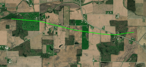
Path of a tornado that touched down just west of the Eel River Golf Course south of Churubusco and tracked rapidly east southeast, crossing US 33 before dissipating in a corn field west of Chase Road. NWS image.

The National Weather Service Northern Indiana weather forecast office (IWX) announced August 2 that it found evidence that a tornado did damage in eastern Whitley County and northwestern Allen County, Indiana at approximately 2:30 a.m. July 29.

“But wait,” you might say, “I never heard about a tornado warning for Allen County that day!” That’s because IWX didn’t issue a tornado warning for this storm. At the time of the tornado, however, a severe thunderstorm warning was in effect that included the words, “tornado possible.”

Most severe thunderstorm warnings do not automatically create alerts on your cell phone.

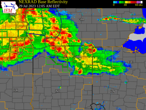
It’s not unusual for the kind of storm we had Saturday morning (a bowing “squall line”) to spawn weak tornados that appear and disappear before the National Weather Service can issue a warning. That’s why, when they warn us of a severe thunderstorm that could contain such tornados, they mention that a tornado is possible.

Weather radar loop slowing the bowing squall line that moved across Indiana early July 29.

It’s also one reason that it’s so important to know about and react appropriately to severe thunderstorm warnings, including those the National Weather Service issues in the middle of the night, when you’re sleeping. But that requires extra effort on your part, because most severe thunderstorm warnings do not automatically create alerts on your cell phone.

If you’ve ever been someplace covered by a tornado warning, you probably received a Wireless Emergency Alert (WEA) on your phone, even if you never installed a weather app. That’s because all modern smartphones come with WEAs enabled and all tornado warnings prompt WEAs.

The only severe thunderstorm warnings that trigger WEAs, however, are those in which the National Weather Service includes a “destructive” damage threat “tag.” They do that for storms that have either hail that’s at least 2.75 inches in diameter (baseball-sized) and/or 80 mph straight-line thunderstorm winds. According to Saturday morning’s severe thunderstorm warning, meteorologists expected winds of up to 60 mph and no large hail. That warning therefore did not trigger a WEA.

So, how can you know if a storm like Saturday’s is headed toward your home in the middle of the night, while you’re asleep? I know of two really good ways:

  1. Buy a weather alert radio and keep it near enough to your bedroom to wake you.
  2. Install a weather alert app, like Storm Shield, and configure it to alert you to severe thunderstorm warnings.

When the NWS issues a severe thunderstorm warning for your location, the best way to be safe is to do the same thing you’d do in a tornado warning. Move to the most interior room on the lowest level of your house. This will provide the best protection from a brief tornado, like the one that touched down July 29 and from straight-line thunderstorm winds dropping a tree limb on your house, which is what killed a woman in Ohio City, Ohio July 20.

University demonstrates questionable understanding of tornado warnings

It’s really important that anyone who is in charge of the safety of an institution — a university campus, for example — maintain an updated, working knowledge of how weather warnings work. Tweets sent today by Indiana University today could lead one to believe that its campus safety staff could benefit from some education in that area.

At 1:19 p.m. EST, the Indianapolis office of the National Weather Service (NWS) issued a tornado warning that included a portion of southern Monroe County, Indiana.  The warning came with a polygon that clearly showed that the IU campus was not included.

Polygon associated with Nov. 5 tornado warning near Bloomington, IN. The National Weather Service issued the warning only for the area inside the red polygon.

In addition, the text of the warning indicated that “a severe thunderstorm capable of producing a tornado was located 12 miles northwest of Bedford, moving east at 30 mph.” In other words, the storm was not moving toward Bloomington or the IU campus (which is why NWS meteorologists drew the polygon as they did).

Six minutes after the NWS issued the warning, IU sent a tweet at 1:25 regarding what it called a “tornado warning for Bloomington.”

Cody Kirkpatrick, an IU lecturer in atmospheric science, attempted to clarify IU’s tweet:

The IU Twitter account replied:

Dr. Kirkpatrick knew what he was talking about. Those sending tweets on behalf of IU demonstrated ignorance of the National Weather Service’s “storm-based warning” system. When the NWS implemented that system a decade ago, it replaced the county-wide warnings to which IU’s tweet refers, with warnings based on polygons that indicate where the actual risk is.

In subsequent tweets, Dr. Kirkpatrick attempted to point that out, as well as the fact that IU’s original tweet was ambiguous. IU’s response:

But is warning people who are not at risk really better than warning only people who are truly at risk? Is doing so truly “safe,” or does it exacerbate existing challenges with getting people to respond appropriately to warnings?

The people at any institution like IU, who are in charge of disseminating public safety information, would do well to take full advantage of the informational resources that exist among their own faculty. Doing so could lead to better weather safety communications in the future.

What residents need to know about their new outdoor warning siren

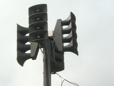
Tornado siren. Outdoor warning sirens are not intended to be heard indoors.

Blogger’s note: Below is an article I submitted to the “The Waynedale News,” a neighborhood newspaper in Fort Wayne, Indiana. If refers to the installation of an outdoor warning siren in a neighborhood that had been without one for years. The newspaper published the article July 7, 2017.

The new outdoor warning siren that’s coming to Waynedale brings with it some true risks that area residents might not have considered. Chief among those risks are over reliance and desensitization. Continue reading

Remembering a lesson on a derecho anniversary

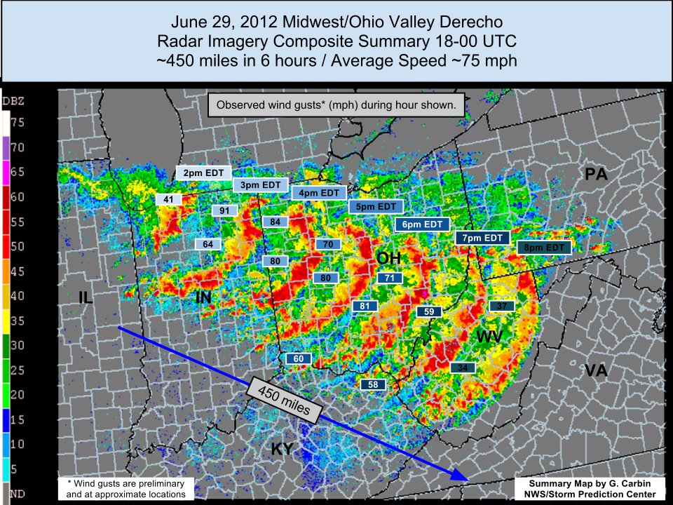
An NWS graphic showing the path of the 2012 derecho

Today is the fifth anniversary of a “derecho” thunderstorm that did widespread damage in northern Indiana and locations to the southeast.

“At the peak of the event,” writes the northern Indiana office of the National Weather Service, “the Fort Wayne International Airport observing equipment observed a peak wind gust of 91 mph.”

“Winds were as strong as an EF-1 tornado over a widespread area,” the NWS web page continues, “which resulted in immense damage along the storm’s entire path.” (Emphasis added by W9LW.)

One of the best lessons of that storm should be that we can have massive damage without a tornado. This was a particularly dangerous severe thunderstorm, but there’s no such thing as a “particularly dangerous situation” thunderstorm warning, so we need to pay attention to all severe thunderstorm warnings, even though such warnings are not uncommon.

See an extensive discussion of the 2012 derecho on the NWS northern Indiana website: https://www.weather.gov/iwx/20120629_derecho

Top 5 ways to get severe weather warnings

(Updated March 31, 2025)

It’s hard to protect yourself and your family from tornados, damaging straight-line severe thunderstorm winds, or large hail, if you don’t know that the National Weather Service has issued a tornado or severe thunderstorm warning for your location.

So, here’s my list of the best ways to get tornado, severe thunderstorm and flash flood warnings.

Continue reading

Know anyone who’s still confused by watch vs. warning?

Wizard of Oz witch tornado watch warning meme
Meme creator unknown

The U.S. National Weather Service has been issuing tornado and severe thunderstorm watches and warnings since 1965. More than 50 years later, however, people still fail to fully understand the difference between a watch and a warning. You probably know some of them, I certainly do.

As my contribution to the second day of Indiana’s Severe Weather Preparedness Week 2016, I’ve written this blog to share with your friends and family members who remain confused.

A watch is essentially a forecast

Map showing tornado watch for a large part of Indiana and Michigan for 11:20 a.m. to 8 p.m. Nov. 17, 2013.

In fact, before 1965, the NWS called what we now know as “tornado watches” “tornado forecasts.” A tornado watch indicates the possibility of tornadoes forming, just as a rain forecast indicates the probability of rain. Similarly, a severe thunderstorm watch indicates the possibility of severe thunderstorms forming. A watch does not mean these things are already happening, it means they could happen.

Like a forecast, a watch covers a period of many hours and usually covers a large area of at least several counties, if not several states. We should watch for possible dangerous weather in the near future.

A warning is an indication of immediate danger

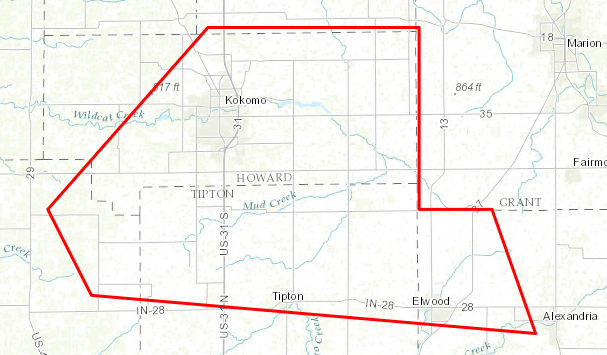
Polygon indicating the area covered by a tornado warning for the Kokomo, Indiana area Nov. 17, 2013.
Polygon indicating the area covered by a tornado warning for the Kokomo, Indiana area from 3:17 p.m. to 3:45 p.m. Nov. 17, 2013. Click the image to see a larger version.

It’s a call to take shelter now, because the tornado or severe thunderstorm is already happening. Depending on where you are, you might only have couple of minutes to protect yourself and your family. Or, you might have 10 or 15 minutes, if you’re at the far edge of the “warning polygon.” If you want to survive a tornado or a severe thunderstorm, don’t waste time seeking more information. When a warning comes out, take shelter immediately.

Because dangerous weather has already formed and is on its way, a warning usually covers a period of less than an hour and a small area that’s sometimes smaller than a county. The time to watch is over. It’s now time to heed the warning and take shelter.

Want even more lead time?

If you’re really interested in weather, or want to know even earlier whether severe weather is possible, there are two other NWS products to check out.

The NWS Storm Prediction Center (SPC) usually issues a “mesoscale discussion” before it issues a watch. This product lets you know that the SPC is thinking about (or planning to) issue a watch, the geographical area of concern and the reasons. Some of the text of a mesoscale discussion can get pretty technical, but anyone can figure out from this product whether a watch is likely to be issued. If any mesoscale discussions are in effect, you can find them on the SPC website.

For even more lead time, the SPC issues “convective outlooks” that indicate the amount of risk of severe weather as much as eight days in advance. You can also find these products on the SPC website.

Has technology led people to believe storm spotters are no longer necessary?

Storm spotter capturing image of developing tornado with cell phonesIt’s amazing how much information I can get on my smartphone, especially weather information. The app stores have dozens — maybe hundreds — of weather apps. They offer much more than today’s forecast. Some even claim to tell users when it will start raining at their locations.

Regardless of how valid or accurate is the information such apps provide, I wonder if they’ve led people to (incorrectly) believe that technology has the weather covered — that there’s little need anymore for human input, such as that provided by trained, SKYWARN® storm spotters.

Do people assume that the same technology that tells them what time the rain will begin can also automatically sense such hazards as tornadoes and severe thunderstorms?

If so, that could help explain why registration is down this year for free National Weather Service storm spotter classes in northern Indiana, northwestern Ohio and southern Lower Michigan.

For example, as of Jan. 25, fewer than 10 people had registered for spotter classes scheduled in Columbia City, Ind. and Glandorf, Ohio. This, despite frequent promotion on social media and other channels by the northern Indiana NWS office and others.

The entire severe weather warning system continues to rely heavily on the first-hand reports of trained spotters.

The truth — as any meteorologist will tell you — is that the entire severe weather warning system continues to rely heavily on the first-hand reports of trained spotters. Why? Because they can see things that radar and other technology cannot.

Radar, for example, can detect rotation in a storm, hundreds to thousands of feet above the ground. But it cannot tell meteorologists whether a funnel cloud has formed or whether a tornado is on the ground. Also, technology cannot tell meteorologists what damage a storm is doing. The NWS needs eye-witness reports from trained spotters for that.

If you’ve ever looked up a scary-looking cloud and wondered if you should worry;

If you’d like a better understand of severe weather to help allay fears;

If you’re a weather enthusiast and would like to apply that interest in a way that provides a life-saving service to your community;

Consider taking the free storm spotter training. You can find a session near you on the website of your local NWS office (type in your ZIP code at www.weather.gov and then look for the link on the forecast page that follows the phrase, “Your local forecast office is”). Some sessions begin as early as next week, so don’t put it off until storm season begins!

As good as weather technology is, it has not replaced they eyes of trained, volunteer storm spotters. Your community needs you!

Palm Sunday tornado tweets a must read for weather, history buffs

Anyone interested in severe weather, history, or both will greatly appreciate a series of posts that the National Weather Service northern Indiana weather forecast office (WFO) published on the micro-blogging site Twitter yesterday.

And the WFO’s staff should be commended for excellent work gathering a great deal of historical information about the April 11, 1965 Palm Sunday tornado outbreak and for presenting it in such a compelling way.

The WFO prepared more than 100 tweets, many with images of actual text products issued via teletype the day of the outbreak. Other tweets contained Google maps with tornado tracks marked on them and photos of the tornadoes taken by citizens and photojournalists.

To add to the drama, the WFO scheduled each tweet to appear on Twitter at times coincident with the actual times of day that the events occurred. Genius.

The WFO’s series of tweets gives viewers a real sense of how different severe weather forecasting, detection and warnings were 50 years ago. For example, one thing that struck me was the Fort Wayne Weather Bureau office relaying to local broadcast media via teletype word of tornadoes in the Lafayette area. These days, because of better detection and communication technology, you rarely see WFOs issuing text products regarding tornadoes that distant.

If you missed the live tweets yesterday, you’re in luck, because they’re still visible on the Twitter website, even to people who do not have Twitter accounts. Just follow this link. When you get there, scroll down to a point near the bottom of the page to the tweet that reads, “We are beginning the live tweet of the events of 4/11/65, the Palm Sunday Tornado Outbreak,” and then read your way up from there.

I highly recommend it.


Americans risking their lives listening for sound they can’t hear

“There are millions of people across this country putting their lives on the line by listening for a sound they can’t hear.”

Relying on outdoor warning sirens is dangerous (photo of a siren)That’s my favorite line from a 2015 blog post by weather journalist Dennis Mersereau on now defunct “The Vane” blog.

Mersereau makes a strong case for a difficult change in mindset: relying on warning technology that’s more modern and reliable than the ubiquitous outdoor warning siren.

I’ve written about this topic myself. I’ve seen (as I imagine Mersereau has) more than one post-tornado report from the National Weather Service (NWS) that indicated victims failed to seek shelter after the NWS issued a warning, because they didn’t hear sirens. This has been true even for people who knew about the warning because they heard it on TV, saw it on Twitter, etc.

The main thesis of Mersereau’s post is absolutely correct: Communities will save a lot more lives spending money on free NOAA Weather Radio receivers for citizens than in upgrading or installing outdoor warning sirens.

But despite that facts that Mersereau presents, the average citizen doesn’t see it that way.  You see, we have relied on outdoor warning sirens for so long (ever since the post-WWII re-purposing of air raid sirens — and that’s a long time) that they’ve become a strong tradition. I’d argue they’ve become an almost inextricable part of our culture.

As a case in point, (as I pointed out in my 2014 post linked above), I invite you to watch an Indianapolis Colts football game, where the stadium public address system often plays a warning siren sound effect. Why? Not because a storm is on the way, but because Colts staff members know that an emotional response to that sound is ingrained in fans.

The fact that the Colts use that sound effect in that way is evidence that outdoor warning sirens have become a part of our collective psyche. That’s hard to fight.

More evidence comes from the vehement arguments that siren-lovers have posted in comments beneath Mersereau’s blog post. As Mersereau put it in a tweet to me, “People believe in their sirens like a religion.”

That, my friends, is the real problem.

It will take a lot of public education (like Mersereau’s blog post) over a significant period of time to change that.

In the meantime, citizens will continue to expect their elected officials to spend money on an outdated, ineffective warning technology.

Meteorologist Jason Meyers spins up a video explanation of “gustnadoes”

Here’s a good explanation of “gustnadoes” by meteorologist Jason Meyers of the Storm Shield App: