Category Archives: SKYWARN

Better alternatives to tornado sirens

Photo of outdoor warning siren with superimposed text "For outdoor reception only"Earlier, I wrote a post titled, “Stop believing in tornado sirens.” I hoped it would help convince readers that the decades-old technology is not the best way to learn of severe weather threats.

Now, here’s a bit more about better alternatives.

Weather alert radios

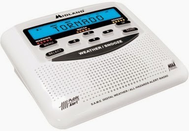
Photo of weather radioIn the earlier post, I mentioned weather alert radios. There are several manufacturers and models. What you want is one that supports Specific Area Message Encoding (SAME). It’s a system that allows weather radios to remain silent until a warning is issued for your own county. This means there’s never any reason to turn off the radio. One of the least expensive is the Midland WR120. I’ve seen it priced at under $35. It’s available at most Walgreens pharmacies, as well as other local retailers. There are plenty of other choices. Just do a search on Amazon or any other shopping website for “weather alert radio same.”

Smartphone apps

Logo for American Red Cross tornado appSmartphone apps are another option. They have the advantage of using the phone’s GPS to know where you are and alert you of warnings for that location, even when you’re away from home. Be sure to choose an app that make a loud enough noise to wake you.

I’ve tested the Storm Shield App from the E.W. Scripps Company. It’s available for iOS and Android.

Wireless emergency alerts logoBy the way, if you have a new enough smartphone, it probably supports Wireless Emergency Alerts (WEA), which means that even without installing an app, the phone will sound off when a tornado warning is issued for wherever you are. It depends on the device and the cell phone company. My old iPhone 4 did not support WEA, but the newer iPhone 4S does. Follow the link at the beginning of this paragraph to find out if your phone supports WEA.

I know of no other options that will wake you in the middle of the night. But during the daytime and evening when you’re still up, the following resources can be helpful:

Text messaging

Many local TV stations send subscribers text messages when the NWS issues weather warnings. Just visit the website of your favorite station to see what it offers.

Other websites also offer text messaging, some for free and some for a fee, including:

Not that if a storm destroys your nearest cell phone tower, that might keep you from getting text messages on time.

Local broadcast radio and television

If you know a watch has been issued, you can learn of warnings by keeping a radio or TV on and tuned to a local station. Most will automatically interrupt programming when the NWS issues a warning for their listening/viewing areas.

Social Media

Local broadcasters and the NWS often post news of weather warnings on Twitter and Facebook. Social media, however, should never be your primary source of warning information, because warnings might not appear promptly enough.

Know someone who could benefit from this information? Use the sharing buttons below to share it with your own social networks. Feel free to submit a comment if you have other suggestions for weather radios and/or other sources of severe weather information.

Stop believing in tornado sirens!

Photo of tornado siren

In support of Indiana’s Severe Weather Preparedness Week (March 16 – 22), I plan to post a series of articles on this blog. Some will be targeted at my readers who are members of the general public and others will be intended for trained SKYWARN storm spotters.

This first instalment in the series is for everyone; especially everyone who thinks tornado sirens will keep them safe from severe weather.

Tornado sirens are something of a tradition in the Midwest. For many of us, the very sound of a tornado siren creates an emotional response – which is why some NFL teams play recordings of tornado sirens during games. These sirens are so woven into our culture that many Midwesterners dangerously assume that if a tornado threatens their town/city/neighborhood, they’ll hear a tornado siren. Just as dangerously, many believe that if they don’t hear a siren, there’s no real danger.

In fact, very few communities have enough tornado sirens to protect all residents. And no sirens are intended to be heard indoors. So, if you rely solely on sirens to keep you safe, chances are very high that even if a tornado is bearing down on you and even if it has been spotted, warnings have been issued and sirens activated, you won’t know about it!

Just to give you an idea of how sporadic tornado sirens can be, the area of Allen County, Indiana is 660 square miles. According to the Allen County Office of Homeland Security, only 175 square miles are within range of tornado sirens (“within range” meaning the sirens can be heard by people who are outdoors). That means only 26.5 percent of Allen County’s geography is within range of a tornado siren!

There are other issues with tornado sirens, but I’ll omit them for now. The bottom line is this: Stop believing in tornado sirens. Find other ways to know if you and your family are in danger, even late at night when you’re all asleep. A good start is to buy a weather alert radio, put fresh batteries in it, and program it to sound off when warnings are issued for your county.

Read more about weather alert radios and other alternatives to tornado sirens.

If you think this blog post is helpful, use the buttons below to share it on your Facebook page, Twitter, etc. You might save someone’s life!

Guest blog: Valuable resources for weather historians

1957 weather map
Daily Weather Map from 1957

Guest post by Michael Lewis, KG4KJQ
National Weather Service, Northern Indiana

When I was the science and operations officer in Jackson, Ken. and as the meteorologist in charge in Hastings, Neb., I used to do all kinds of digging through the historic archives for “significant” weather events.

You might find this interesting and there may be others who would as well. This is a must have for every history buff.

U.S. Daily Weather Maps
Publication History

The U.S. Signal Office began publishing weather maps as the War Department Maps on Jan. 1, 1871. When the meteorological activities of the Signal Corps were transferred to the newly-created Weather Bureau in 1891, the title of the weather map changed to the Department of Agriculture Weather Map. In 1913, the title became simply Daily Weather Map. In 1969, the Weather Bureau began publishing a weekly compilation of daily maps with the title Daily Weather Maps (Weekly series).

These maps can be downloaded from the NOAA Central Library: http://www.lib.noaa.gov/collections/imgdocmaps/daily_weather_maps.html

To view/print the maps requires the installation of a free browser plug-in. http://www.caminova.net/en/downloads/download.aspx?id=1

Michael Lewis, KG4KJQ is warning coordination meteorologist at the northern Indiana forecast office of National Weather Service, Syracuse, Ind.

How often do SKYWARN storm spotters need training?

SKYWARN logo
Regarding upcoming SKYWARN training sessions about which I wrote Jan. 15, an experienced spotter asked me a great question, specifically referring to the free, online training that the National Weather Service (NWS) recommends people complete before they attend live training sessions.

This spotter asked, “If we took the course last year to get certified, do we need to take it again prior to this year’s training?”

As I replied to him, the answer depends largely on your definition of “need.” But first, let’s clear up a possible misconception.

The northern Indiana NWS office (IWX) trains SKYWARN severe weather spotters, but it does not certify them. As the office explains on one of its Web pages:

Some NWS offices issue ID’s and/or certificates. However, maintaining such a large database in addition to tracking all the ID’s, can be a difficult task. As a result, this office does not issue ID’s or certificates. The host of each training session, typically the county or city Emergency Manager, can issue and track these, at their discretion.

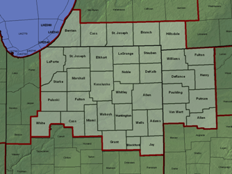
Light green area: County Warning Area (CWA) of the northern Indiana National Weather Service office.

So, if you live in the 37-county warning area (CWA) covered by IWX and think you need recurrent training to maintain an NWS certification, you’re incorrect, only because there’s no such thing as NWS spotter certification in the IWX CWA. But please read on.

The northern Indiana NWS office does maintain a list of trained (not certified) spotters and, “in an effort to maintain an accurate database, spotters who have not received training within 3 years of the their last session will be removed.” So, if you took training (online and/or live) last year, you don’t need to take any training this year to stay on the NWS list of trained spotters. But please read on.

As I wrote above, whether you need training (online or live) this year depends on your own definition of “need.” Unless you are confident that you remember everything you learned last year and that there will be no new information in this year’s training that will be valuable to you, you might need to take both the online and live training again to remain a safe and effective severe weather spotter.

Personally, I plan to go through the online modules again before I attend a live training session this year. And I plan to attend one or more live training sessions as well, plus one or more advanced events (in Indianapolis, Wheaton, Ill., and/or Columbus, Ohio).

Indiana & Michigan Power gets post-storm communication right

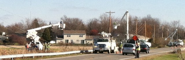
Photo of crews replacing utility poles
I&M crews replace several poles broken by the Nov. 17 severe thunderstorm. (Jay Farlow photo)

I’m really impressed with the communications staff at Indiana and Michigan Power, the AEP branch that sells electricity in Fort Wayne, Indiana, where I live. Here’s why:

After the severe thunderstorms and tornadoes of Nov. 17 rolled through, thousands of I&M customers were without power, including our neighborhood. We live half a mile north of a stretch of road where the wind below down at least seven utility poles in a row.

I&M very effectively used its web site to provide regular updates on the situation. There, I could see estimates of when power would be restored in various locations, or if such estimates were not yet available, estimates of when the estimates would be available! The Web page also provided an explanation of the seriousness of the problem (e.g. the number of utility poles blown down) and information about the utility’s response, including the number of staff members and contractors who were working on service restoration.

I&M published on the same page the date and time of the current update, and the date and time to expect a new update. They updated the page frequently, even outside of business hours.

For me, however, the icing on the cake is this text, which appeared on the page today:

Additional Information
We will be flying Transmission lines in central & western Indiana to inspect the lines for vegetation resulting from the storm. I&M customers may see the helicopter in the Muncie and Fort Wayne areas. Tail Number N105JD Black with Grey Stripes in color.

Look at that! There’s no need for I&M customers who read that Web page to worry when the inspection helicopter flies by. Readers know exactly what to expect, right down to the helicopter’s tail number!

Any company, agency or organization that’s involved in any kind of public service and/or emergency response would do well to pay attention to how effectively I&M communicates information about major power outages. Clearly, I&M understands the value of keeping the public as informed as possible on a very regular basis.

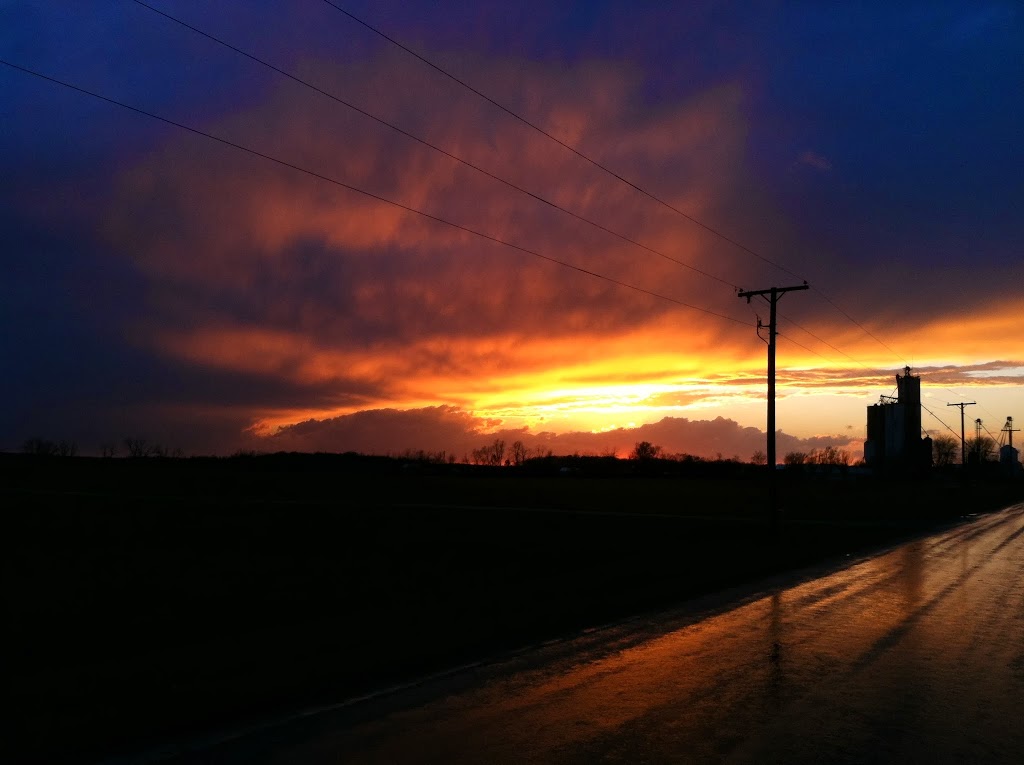
A couple post-storm sunset shots

Southern Allen County, Ind. Photos by Jay Farlow (W9LW), IMO SKYWARN

Public safety officials in Goshen sound tornado false alarm

Whatever agency has responsibility for activating tornado sirens in Goshen essentially sounded a false alarm yesterday.

According to a report in the Goshen News, tornado sirens sounded after Goshen Police received reports of a funnel cloud. The Goshen News report does not say who reported the funnel cloud to police, so we don’t know from that story if any of the calls came from normally credible sources or if they came only from untrained members of the general public. We can assume, however, that the people who reported a funnel cloud to police were probably looking at the cloud shown in the photo below.

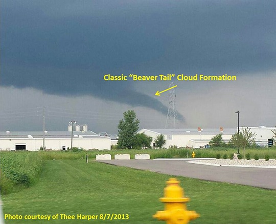
Photo of beaver tail cloud near Gosen
Photo of “beaver tail” cloud near Goshen, from NWS website.

As well-trained SKYWARN storm spotters know, “funnel cloud” has a specific definition in meteorology: It’s a rotating cloud that often exists before or after a tornado. Not every funnel-shaped cloud is a funnel cloud and not every rotating funnel cloud becomes a tornado.

Unfortunately for those in charge of Goshen’s tornado sirens, the cloud that appeared near Goshen was not a rotating funnel cloud and the city was not in danger of a tornado.

National Weather Service (NWS) meteorologists later confirmed that the cloud was a formation known colloquially as a “beaver tail,” which is formed as air cools while being sucked into a thunderstorm, thus allowing water vapor in that air to condense into a cloud. These clouds are normally mostly horizontal. When viewed from a certain angle, however, they can appear to be reaching toward the ground. The northern Indiana NWS office posted an excellent explanation on its website. Their article includes a helpful pair of photos of the same beaver tail taken from two different locations, demonstrating the illusion that can occur.

So, how are people supposed to know the difference? A true funnel cloud rotates. A beaver tail doesn’t. “If it doesn’t spin, don’t call it in,” is a mnemonic I learned in spotter training.

Members of the general public who have never taken SKYWARN training have little way of knowing this. So what’s a public safety agency to do when it gets reports of a funnel cloud from the general public? Here’s my opinion:

  1. Train public safety dispatchers to be aware that some funnel-shaped clouds that might prompt citizens to call 911 are not actual funnel clouds and therefore represent no danger to the community. This knowledge will help dispatches treat funnel cloud reports with a healthy amount of skepticism.
  2. Before sounding tornado sirens, seek confirmation from trained field personnel (e.g. nearby fire fighters, law enforcement officers, EMA volunteers and/or others known to have received SKYWARN training).
  3. Before sounding tornado sirens, place a quick call to the NWS. Ask if atmospheric conditions are right for the formation of tornadoes and whether NWS radar indicates any sign of rotation where the funnel cloud was reported. The NWS office can also tell the local public safety agency whether the NWS office has received any reports from trained spotters that would confirm or contradict public funnel cloud reports.

At the very least, any time a local public safety agency activates tornado sirens on its own (e.g. without an NWS warning), that agency should immediately notify the NWS that it has done so, and why. Why? Because without that notification, nobody who depends on NOAA weather radio or broadcast media for their warnings will know what’s going on!

Not everyone can hear tornado sirens where they live and work. Activating tornado sirens without contacting NWS to activate the entire warning system fails to protect those citizens who are beyond the range of sirens.

What do you think? Please add your comments below. And by the way, please understand that this post represents my personal view, not necessarily the views of any agency or organization.

NWS received delayed info on Peru tornado

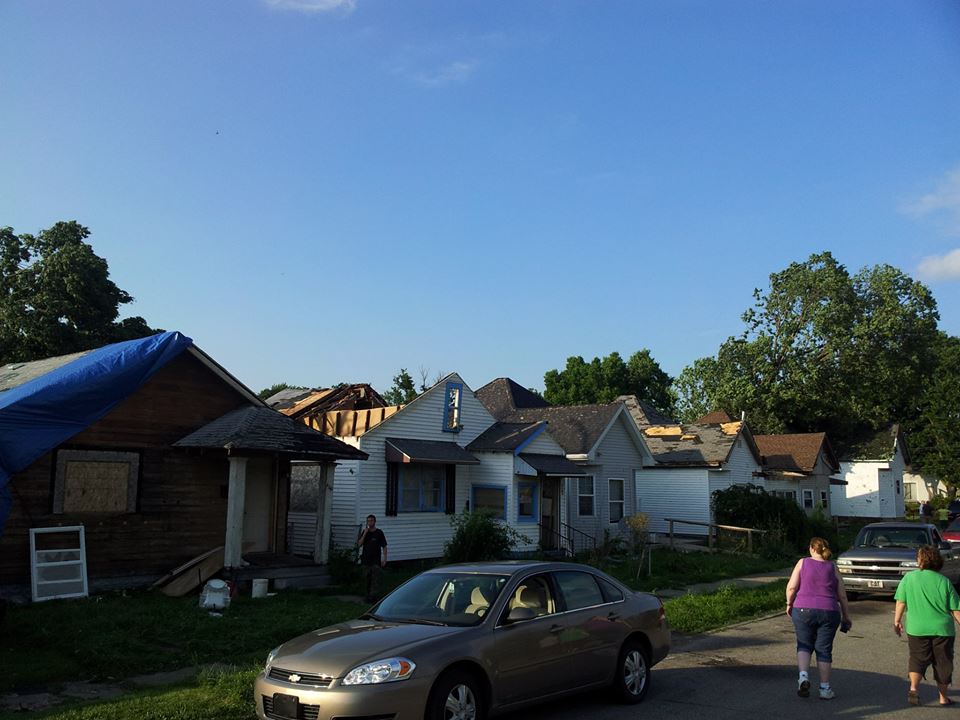
Peru, Indiana homes damaged by July 10, 2013 tornado. Emergency management agency photo from NWS Facebook page.

By guest blogger Michael Lewis, Warning Coordination Meteorologist, National Weather Service, Northern Indiana office

The National Weather Service (NWS) northern Indiana office received delayed reports of storm damage when an EF-1 tornado hit Peru, Indiana July 10. The northern Indiana office is located near North Webster and is responsible for issuing warnings for all of Miami County (of which Peru is county seat). The same office issues warnings for neighboring Wabash and Grant Counties. (See a map of all counties warned by the northern Indiana office.)

It is fortunate that the Peru tornado lasted for only five minutes and 3.5 miles. The absence of first-hand damage reports affected the warning process; requiring National Weather Service forecasters to rely on radar data and limited surface-based meteorological conditions as they issued subsequent warnings. In other words, the lack of timely and credible damage reports made the warning process more challenging. Had reports of damage been received closer to the actual time of occurrence, forecasters would have been able to refocus on other meteorological and radar data, and changed the message and content of the subsequent impact-based warnings.

As the storms continued to organize, strengthen and move east, the Northern Indiana NWS office searched for details of damage in the warned areas. This included searching numerous social media sites, making phone calls and listening to police and fire radio transmissions. The office continued to issue warnings as it gathered reports of wind damage, torrential rainfall and large hail.

Shortly after 3:11 p.m., a Facebook post indicated that damage had occurred in Peru but it didn’t provide complete details.
 
The NWS office received its first reliable information of the situation in Peru at 3:57 p.m., nearly two and a half hours after the tornado struck! At that time, a media partner forwarded a message that an Indianapolis journalist had posted in an Internet chat room devoted to the Indianapolis NWS office. The Indianapolis journalist relayed a report of extensive damage that he received from Kris Marks, the Miami County Emergency Management Agency director.

NWS northern Indiana office meteorologists surveyed the damage in Peru the day after the storm. During that survey, several local officials stated that reports of damage had been forwarded to news media in Indianapolis — not the National Weather Service. During the discussion with several other residents who witnessed the damaging storm, the common statement was that they rely on Indianapolis media because “that’s where they get their weather from.”

Public safety officials and the media in every community need to understand how the weather alert system works. They need to understand that reliable reports of storm damage must be forwarded to the appropriate NWS office as soon as possible.

These reports are critical to a successful warning process. While the damage was already done in Peru, such damage reports critically affect warnings for the next township, community and county over. While the Indianapolis news media broadcasts warning information, official tornado and severe thunderstorm warnings for Miami County and many other counties in the same area originate from the National Weather Service office in northern Indiana. The media cannot issue warnings that trigger the NOAA Weather Radio and Emergency Alert Systems. Any delay in reporting damage to the NWS can therefore significantly affect public safety.

Fortunately in this event, warnings were issued and the event occurred during daylight hours; no lives were lost.  It is critical to understand that the next time we may not be as fortunate.

Failure by local officials to relay reports to the appropriate NWS office hinders the NWS’ ability to issue warnings and prevents the NWS from fulfilling it’s mission of saving lives.


My thanks to Michael Lewis for this first-hand perspective of the issue. -W9LW

Tornado confirmed near Peru, Indiana

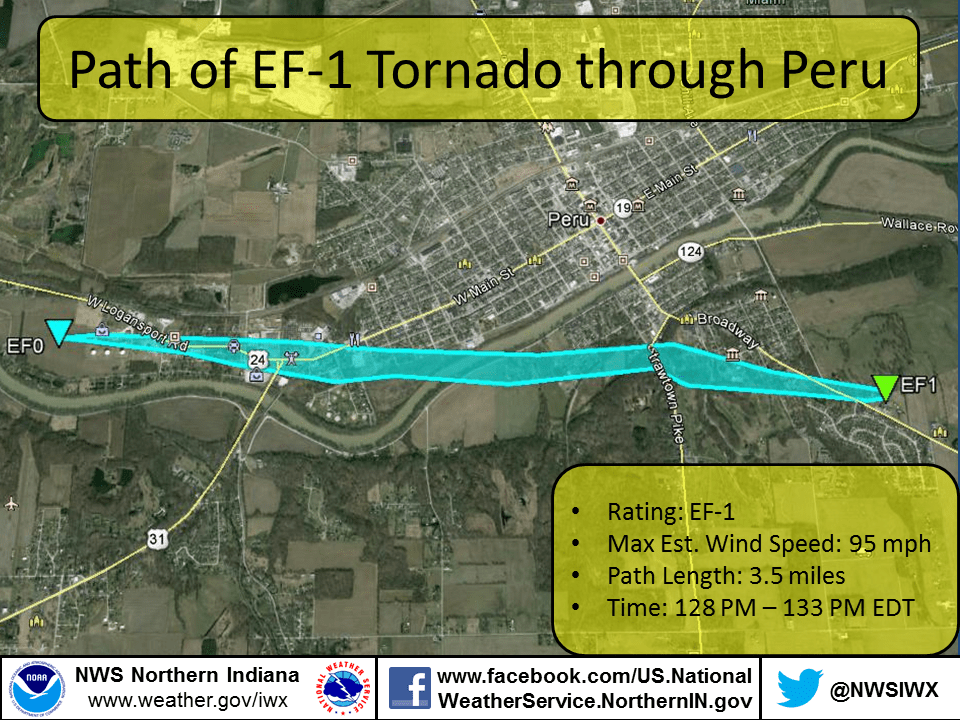
Map showing path of July 10, 2013 Peru, Indiana tornado

A National Weather Service damage survey team confirmed today that an EF-1 tornado touched down near Peru, Indiana July 10. Meteorologists estimate that the twister contained 95 mph winds. It was on the ground for 3.5 miles and lasted only five minutes. See photographs of some of the damage.

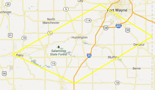
The tornado touched down at 1:28 p.m. NWS had not issued tornado warning. The tornado was probably too small to be detected by Doppler radar. NWS did, however, issue a severe thunderstorm warning for the same area at 1:19 p.m., nine minutes before the tornado touched down. NWS had issued a severe thunderstorm watch that included Miami County at 12:35 p.m., 53 minutes for the tornado touched down.

Map showing coverage area of 1:19 p.m. severe thunderstorm warning
Thunderstorm warning issued at 1:19 p.m. Covered the area within yellow outline.

The moral to this story: Do not ignore severe thunderstorm warnings! Severe thunderstorms can and do produce tornadoes quickly. Plus, even without a tornado, a severe thunderstorm can do as much damage as a weak tornado.

P.S. Thanks to the Iowa Environmental Mesonet website for making it easy to research previous-day warnings, etc.

Tornado Look-Alike Appears over Fort Wayne


Here’s a good training aid for SKYWARN spotters. What does this look like to you?

No, it’s not a tornado or even a funnel cloud. It’s a funnel-shaped rain shaft. You might call it, “virga,” but the technical definition of virga is rain shaft that evaporates before it reaches the ground and the bottom of this rain shaft (the illuminated part) appears to be reaching the ground. I took this photo in the early evening of March 31, 2013 in northeastern Fort Wayne, Indiana.

During SKYWARN training, instructors warn spotters not to confuse rain shafts with funnel clouds. But never before have I seen a rain shaft that so closely mimics the appearance of a funnel cloud.

How did I know it wasn’t a tornadic funnel?

  • It wasn’t spinning (sorry, I didn’t think to shoot video).
  • The weather conditions weren’t right for tornadoes.
  • I could see the rain in the illuminated part at the bottom.

I forwarded this photo to my local NWS weather forecast office to use as a training aid. If you ever see something like this, I encourage you to photograph it and do the same.

Leave a comment below if you’ve ever seen something that looks like funnel cloud or a tornado but wasn’t.