“There are millions of people across this country putting their lives on the line by listening for a sound they can’t hear.”
That’s my favorite line from a 2015 blog post by weather journalist Dennis Mersereau on now defunct “The Vane” blog.
Mersereau makes a strong case for a difficult change in mindset: relying on warning technology that’s more modern and reliable than the ubiquitous outdoor warning siren.
I’ve written about this topic myself. I’ve seen (as I imagine Mersereau has) more than one post-tornado report from the National Weather Service (NWS) that indicated victims failed to seek shelter after the NWS issued a warning, because they didn’t hear sirens. This has been true even for people who knew about the warning because they heard it on TV, saw it on Twitter, etc.
The main thesis of Mersereau’s post is absolutely correct: Communities will save a lot more lives spending money on free NOAA Weather Radio receivers for citizens than in upgrading or installing outdoor warning sirens.
But despite that facts that Mersereau presents, the average citizen doesn’t see it that way. You see, we have relied on outdoor warning sirens for so long (ever since the post-WWII re-purposing of air raid sirens — and that’s a long time) that they’ve become a strong tradition. I’d argue they’ve become an almost inextricable part of our culture.
As a case in point, (as I pointed out in my 2014 post linked above), I invite you to watch an Indianapolis Colts football game, where the stadium public address system often plays a warning siren sound effect. Why? Not because a storm is on the way, but because Colts staff members know that an emotional response to that sound is ingrained in fans.
The fact that the Colts use that sound effect in that way is evidence that outdoor warning sirens have become a part of our collective psyche. That’s hard to fight.
More evidence comes from the vehement arguments that siren-lovers have posted in comments beneath Mersereau’s blog post. As Mersereau put it in a tweet to me, “People believe in their sirens like a religion.”
That, my friends, is the real problem.
It will take a lot of public education (like Mersereau’s blog post) over a significant period of time to change that.
In the meantime, citizens will continue to expect their elected officials to spend money on an outdated, ineffective warning technology.
Sandals, especially flip-flops, which are so popular when the weather is warm, are poor choices for severe weather days.
My feet get warm easily. I have a pair of Chacos brand sandals that I wear almost every day during warm weather. But not on days that I might need to serve as a storm spotter.
If severe weather is coming our way, I usually change into a sturdy pair of ankle-supporting hunting boots I bought on sale at Cabela’s, even if I’ll be staying home during the storm.
Why? On word: debris.
National Weather Service photo
After a storm passes, I might have to walk through storm debris, which can include pieces of trees and pieces of buildings. The walking surface might be uneven. Some of the debris might have sharp edges.
I choose to protect my feet from all that, a practice I learned back in the 90s when I served as an emergency medical technician and communications technician on a Disaster Medical Assistance Team. It’s how I dressed my feet every day, even in tropical weather when assisting the victims of Hurricanes Andrew and Marilyn.
My advice: If you’re a storm spotter or storm chaser, get yourself a good pair of boots to wear anytime you’re in the field, even on hot, humid days. And no matter who you are, if you ever have to take shelter in your house from a coming storm, take the most protective footwear you have with you to the basement, interior room, etc. Put them on after the storm, before you step outside to survey the damage. Your feet will be much safer.
Throughout the week, I’ll use my “W9LW’s Ramblings” blog to help build awareness of important severe weather concepts that everyone should know.
If you’re a trained storm spotter, you’ll already know most of the stuff I’ll write about. In that case, I encourage you to use Indiana Severe Weather Preparedness Week to share this information with your family, friends and co-workers. After all, you are probably the closest thing to a weather expert who those folks know personally.
Today, I’ll start with one of the most basic of severe weather concepts, but also one of the most important; knowing the difference between a severe weather watch and a warning.
The National Weather Service (NWS) has used the term, “watch,” since August of 1965 but I still talk to people who don’t really understand what a watch is and others who refer to watches as warnings and warnings as watches.
Here’s a simple table to help you remember the difference. The information below applies to both tornado and severe thunderstorm warnings and watches.
Warning
Watch
Your response
Take shelter now!
Remain alert, determine where you’ll take shelter if necessary
Meaning
Severe weather is imminent, has been detected by radar and/or confirmed by trained weather spotters
Conditions are favorable for the development of severe weather in and close to the watch area
Timeframe
Minutes before danger arrives
Usually hours before severe weather occurs
Geography
Very local, sometimes less than a county, based on storm location and track
Regional, multiple counties, often crossing state lines, based on atmospheric conditions
Bottom line: When the NWS issues a warning, it’s time to take action. Now. When the NWS issues a watch, it’s time to make sure you’ll know about a warning if one comes out later and time to make sure you know what you’ll do if a warning comes out.
Please share this! Do you know someone who doesn’t really understand watches and warnings? Use the buttons below to share a link with your social networks, etc.
Meteorologists from the Memphis NWS office presented a two-hour SKYWARN spotter training session via Google Hangouts and you can see a recording of the entire thing on YouTube.
The recording provides useful and interesting information, but viewers should not assume that their local NWS offices will recognize the program as official spotter training. The northern Indiana NWS office does not, according to Michael Lewis, that office’s warning coordination meteorologist.
At the time of this writing, the only ways to be recognized by the northern Indiana office as a trained spotter are to attend an in-person training session sanctioned by that office or complete MetEd online training, Lewis said.
Of course, taking training recognized by your local office matters only if you wish to on that office’s official list of trained spotters, which can help improve the credibility of any reports you make to that office. In my experience, the northern Indiana NWS office accepts reports from anyone, trained or not. But reports that come from spotters they recognize has having received official training probably have a greater effect on meteorological decision making.
If you read convective outlooks as much as I do (especially during severe storm season), you’ll likely encounter a reference to a “shortwave,” which is an abbreviated way to mentioning a shortwave trough (area of low pressure) in the atmosphere. Shortwaves can help create thunderstorms.
Meteorologist Jason Myers published an excellent, short video explanation of shortwaves. Check it out, it’ll only take you 65 seconds!
I’ve wondered for a while whether tornado sirens (or, as emergency managers often call them, “outdoor warning sirens”) have become so ingrained in our culture over the past several decades that people instinctively treat them as our most important (if not our only) method to receive warning of impending weather danger.
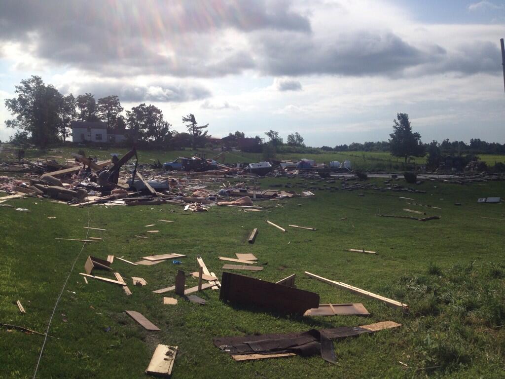
Tornado damage in Smithfield, NY (NWS photo)
Lately, I’ve seen evidence that this is unfortunately the case. It would be unfortunate, because such sirens were never intended to provide warning to people who are indoors and because many, many communities (including the Indiana community in which I live) don’t have enough warning sirens to assure that every person in the community can hear them, even when outdoors.
Why do I think our culture nonetheless puts too much stock in tornado sirens? Here’s one case in point: CBS Evening News reporter Vinita Nair did a report July 9 about a rare New York State tornado that killed four people in the town of Smithfield. In part of her report, Nair said, “Smithfield doesn’t even have tornado sirens.” What prompted that line in her report? I submit that its inclusion indicates how widely-held is the belief that tornado sirens are a primary way to receiving warning of impending danger.
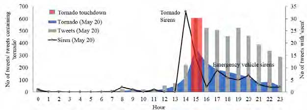
Here’s more evidence to consider. At the 11th International Information Systems for Crisis Response and Management (ISCRAM) Conference in University Park, Pennsylvania, last May, seven authors presented “Tweeting and Tornadoes,” an academic paper that examines the content of geo-located Twitter messages (tweets) sent on the microblog social network during the Moore, Oklahoma tornado of May 20, 2013. Among other findings, the authors noted that the volume of tweets spiked significantly when tornado sirens became audible to Twitter users (see the graph below).
Figure from Blanford, et. al., “Tweeting and Tornadoes”: Temporal distribution of tweets with at least one keyword (gray bars) (e.g., ‘storm’, ‘weather’, ‘take/ing cover’, ‘shelter’, ‘pray’, ‘emergency’, ‘red cross’, ‘help’ and ‘devast’, ‘destruct’, and ‘donat’ in relation to tweets containing the keyword ‘tornado’ (blue area) or ‘siren’ (black line) and how these related to the tornado event (red bar). Tweets were summarized for each hour.
The authors write, “Sirens in Moore were sounded six times with the initial siren occurring shortly after the first NWS tornado warning was sent (14:41hr) with the final warning at 15:20hr (Kuligowski et al., 2013). The first mention of sirens also begins at 14:41hr (N=22 tweets in 4 minutes) with tweets such as ‘Sirens going off now!! Take cover…be safe!’, ‘Sirens sirens sirens. Becoming so real’, and ‘If u hear a tornado siren, uve got 6-8 minutes…’”
The tweet that included the words “becoming so real” particularly got my attention. It almost seems as if the writer of that tweet did not begin to appreciate the seriousness of the situation, until she heard sirens. And it came from a person who was obviously connected to the Internet (either via computer or smartphone) and therefore had at her disposal official tweets from NWS and other information sources to enhance situational awareness before sirens sounded.
If, in fact, sirens have become so ingrained in our culture that we need them for motivation when severe weather threatens, I consider that a dangerous trait. Too many of us will never hear a siren, even if a tornado is about to destroy the home we’re in. Even a person who lives close to a siren will likely never hear it just before a non-tornadic severe thunderstorm drops a tree on his house and kills him (because many, if not most, communities don’t sound tornado sirens for severe thunderstorms without imminent tornado threats).
How do we remove tornado sirens from their strongly held homes deep in our collective psyche? Perhaps we can’t. But it sure wouldn’t hurt if trusted news sources and public officials continue to share information with their audiences and constituents about the shortcomings of tornado warning sirens, the necessity of having alternative means of receiving warnings and the importance of reacting immediately and appropriately to those warnings, regardless of whether a tornado siren is audible. Likewise, if you’re reading this blog, chances are good that you’re the severe weather expert in your family, circle of friends, church, etc. You can help to, by spreading the word in your community.
The sound of a tornado siren is so motivating and our response to the sound is so emotional, that the Indianapolis Colts NFL football team uses that sound to rile up the fans during home games at Lucas Oil Stadium. We might never change the emotion associated with that sound. But perhaps we can help protect our communities by doing what we can to build up the importance of other warning methods.
If we’re successful, perhaps someday, the sound of a weather alert radio’s alarm will prompt a tweet like, “Weather radio sounding off. This is becoming so real.”
What do you think? Add your comments to this post (there’s a link right under the title).
1) Storm chasers are not saving lives. In fact, storm chasers sometimes put themselves at risk and further burden local emergency managers should they require assistance. Chasers call this phenomenon “chaser convergence,” and it sometimes crowds rural and remote roadways to the point that emergency vehicles can no longer pass.
I think “Slate” author Eric Holthaus over generalizes a bit when he writes, “Storm chasers are not saving lives.”
Some chasers are true scientists who conduct research that might someday save lives by enabling improved forecasts, for example. And some chasers act as both chasers and SKYWARN storm spotters when in the field — in other words, these chasers report the severe weather they see to the nearest National Weather Service office.
Chasers who do bona fide research and those who make reports to the NWS might be saving lives, either in the long term or short term. On the other hand, Holthaus might be correct, if he refers to the remainder of chasers, who neither do true research nor call in reports.
A 14-year-old Winona Lake boy died early this morning when a large tree fell on a mobile home, according to a preliminary summary of local storm reports issued by the northern Indiana office of the National Weather Service at 8:14 a.m. The NWS attributes the report to Kosciusko County’s emergency management agency, which reported that the fatality occurred at 1:20 a.m.
The NWS had issued a severe thunderstorm warning at 1:02 a.m. for an area that included Winona Lake. The warning was in effect until 1:45 a.m. and included the following language:
* AT 100 AM EDT...SEVERE THUNDERSTORMS WERE LOCATED ALONG A LINE
  EXTENDING FROM 6 MILES NORTHEAST OF MENTONE TO 8 MILES SOUTHWEST OF
  AKRON...AND MOVING EAST AT 55 MPH.

  HAZARD...70 MPH WIND GUSTS.

  SOURCE...RADAR INDICATED.

  IMPACT...EXPECT CONSIDERABLE TREE DAMAGE. DAMAGE IS LIKELY TO
           MOBILE HOMES...ROOFS AND OUTBUILDINGS.

* LOCATIONS IMPACTED INCLUDE...
  WARSAW...WINONA LAKE...NORTH MANCHESTER...TRI-LAKES...COLUMBIA
  CITY...HUNTINGTON...AKRON...PIERCETON...SOUTH WHITLEY...BURKET...
  PALESTINE...BEAVER DAM LAKE...CLUNETTE...GILEAD...MONOQUET...
  DISKO...CLAYPOOL...STOCKDALE...SILVER LAKE AND ROANN.
That warning should not have surprised anyone, because all of Kosciusko County had been under severe thunderstorm watch number 381 since 11:35 p.m. Monday night.
As of the time of this writing, the NWS was working with emergency managers throughout its 37-county warning area to determine whether to send out storm survey teams and if so, where to send them.
Below is summary of storm damage reports, issued by the NWS at 8:14 a.m. EDT.
PRELIMINARY LOCAL STORM REPORT...SUMMARY NATIONAL WEATHER SERVICE NORTHERN INDIANA 814 AM EDT TUE JUL 01 2014
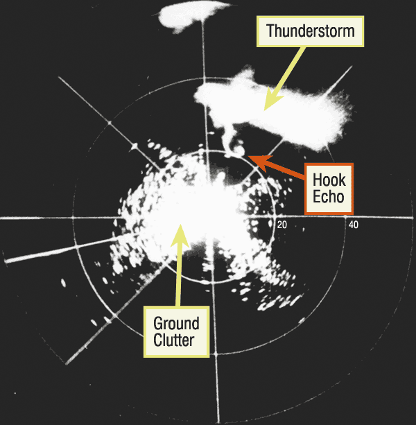
Meteorologists in Illinois documented the first radar hook echo on this date in 1953. This was a major turning point in monitoring severe weather, demonstrating that tornadoes could be identified by radar. This discovery helped lead to the first national weather radar network in the United States.
First recorded radar hook echo of a tornado, April 9, 1953, near Champaign, IL (photo courtesy of the Illinois State Water Survey, INRS, University of Illinois).

 That’s my favorite line from a 2015 blog post by weather journalist Dennis Mersereau on now defunct “The Vane” blog.