Tornado Look-Alike Appears over Fort Wayne


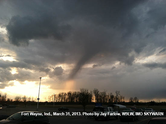
Here’s a good training aid for SKYWARN spotters. What does this look like to you?

No, it’s not a tornado or even a funnel cloud. It’s a funnel-shaped rain shaft. You might call it, “virga,” but the technical definition of virga is rain shaft that evaporates before it reaches the ground and the bottom of this rain shaft (the illuminated part) appears to be reaching the ground. I took this photo in the early evening of March 31, 2013 in northeastern Fort Wayne, Indiana.

During SKYWARN training, instructors warn spotters not to confuse rain shafts with funnel clouds. But never before have I seen a rain shaft that so closely mimics the appearance of a funnel cloud.

How did I know it wasn’t a tornadic funnel?

  • It wasn’t spinning (sorry, I didn’t think to shoot video).
  • The weather conditions weren’t right for tornadoes.
  • I could see the rain in the illuminated part at the bottom.

I forwarded this photo to my local NWS weather forecast office to use as a training aid. If you ever see something like this, I encourage you to photograph it and do the same.

Leave a comment below if you’ve ever seen something that looks like funnel cloud or a tornado but wasn’t.

Are Ham Radio SKYWARN Spotters Becoming Irrelevant?


Are ham radio SKYWARN spotters becoming irrelevant, the way that ubiquitous cell phones reduced the importance of repeater autopatches? Comments at a recent meeting hosted by the Northern Indiana National Weather Service could lead one to believe that answer is, “Perhaps.”
The Northern Indiana NWS weather forecast office conducted a workshop October 17 for its Integrated Warning Team (IWT). By NWS definition, an IWT includes the local NWS office, news media and emergency management community. The purpose of the workshop was to find ways to increase data sharing between the three components of the IWT. Representatives of each of the three IWT segments gave presentations on their needs. The comments of the NWS representatives were particularly interesting.
“The only way we really know what’s going on is when we get that ground truth report,” said an NWS presenter. Unfortunately, the NWS is not receiving enough timely reports from its trained spotters. An NWS representative expressed frustration at seeing significant radar data in an area where he knew trained spotters lived but getting no reports.
When reports don’t arrive via traditional means (like ham radio, or messages from emergency officials), the NWS has no choice but to search elsewhere for information. It has started searching on social media networks like Facebook and especially Twitter. It turns out that users of social media often write about the weather they see, because they believe their friends and followers are interested. Members of the IWT acknowledged that most such reports come from people without any weather training. But many social media users send their updates from camera-equipped smart phones and include photos with their reports.
“One picture of a funnel cloud is better than 10 reports from trained spotters,” an NWS representative said.
Does that mean ham radio operators should abandon SKYWARN nets? Perhaps not. But it might be wise to take steps to improve the value of our service. Here are some ideas to consider:

  • Education. By learning all we can about meteorology, we can assure that all our reports are valid and valuable.
  • Technology. By becoming familiar with and using other technologies to supplement ham radio (e.g. tweeting photos from smart phones), we can provide a more complete service while demonstrating our ability to stay on the “cutting edge.”
  • Procedures. By insisting on sounding as professional as possible when we communicate, we can build credibility among any IWT members who monitor or receive our reports.

In upcoming articles, I’ll share more ideas along these lines, especially ways to gain more education and use technology.

Storm Spotters as Advocates

If you’re a trained SKYWARN storm spotter, who in your family knows more than you about severe weather? How about in your neighborhood, place of employment or place of worship?

Unlike most of your family, friends and coworkers, you know that a tornado watch means that conditions are favorable for the development of tornadoes and a tornado warning means it’s time to take cover. You know that flooding kills more people in northern Indiana than do tornadoes. You know that most people cannot rely on tornado sirens to warn them of danger.

Chances are, in most (if not all) of your circles, you are the severe weather expert.

I’d like to propose, therefore, that you have more responsibility than observing and reporting severe weather. You should also be a weather safety advocate.

I wrote in a previous post that many residents of Joplin, Missouri initially ignored warnings of the tornado that would devastate part of their city. Compared to years past, the National Weather Service is able to issue more specific warnings earlier than ever before. But for too many people, these advances are wasted, because they don’t know how to react to the information. That’s where you come in.

Be an advocate. Advise your friends and family to buy weather alert radios. Help program the radios. Help them learn how to interpret and react to severe weather information. Make sure they know that a tornado warning means “take shelter,” not “go outdoors to look.” Teach them they’re not necessarily in the clear just because 10 minutes have passed without a tornado.

We can be the best possible weather spotters but if the people we’re trying to protect don’t know what to do, what’s the point?

“Warning Desensitization” Makes SKYWARN Spotters even more Important

As I wrote earlier, I attended a severe weather symposium March 2, the same day that southern Indiana got slammed by tornadoes. In this post, I’ll share a little more about that conference.
It was the 16th Annual Sever Weather Symposium, organized and hosted by The Ohio State University’s Meteorology Club. This was not storm spotter training or even advanced spotter training. But any spotter who is interested in learning more about severe weather would do well to attend future instances of this symposium.
I was particularly interested in a presentation by Gary Garnet, warning coordination meteorologist, National Weather Service Cleveland, Ohio weather forecast office. Garnet spoke on “Findings from the Joplin Tornado Assessment.” His presentation about the devastating tornado strike in Joplin, Missouri on May 22, 2011 did not focus on meteorology. Rather, he reported on a study he helped to conduct to assess “issues ranging from internal NWS warning operations to dissemination strategies to public warning response.” Garnet and other team members had conducted nearly 100 interviews in Joplin with tornado survivors, business people, media representatives as well as emergency management, NWS and local government officials. The team’s full report is available on the Web.

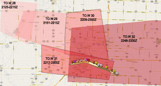
Tornado warnings issued before and during the Joplin tornado. Notice how some of the warning polygons overlap. Graphic courtesy NWS.
Garnet reported that due to warning desensitization, most Joplin residents did not take immediate action when they learned of the NWS tornado warning. Instead, most sought additional information, including going outside to look for the storm, eating away at the 21 minutes between the warning and the beginning of EF-4 tornado damage.

Garnet said “non-routine triggers” are what eventually prompted citizens to take action to protect themselves. For example, Joplin officials broke from their normal practice and sounded tornado sirens more than once. Broadcasters began imploring listeners to “take cover now,” something listeners were not accustomed to hearing.
In some ways, the weather service’s relatively new practice of basing warning areas on storm movement, rather than county lines, adds to the problem. Making warning areas more specific is a good idea but NOAA weather radio still alerts entire counties and many (if not most) tornado siren systems lack the ability to selectively activate sirens. In addition, subsequent warning polygons often overlap each other, confusing citizens.
So, what does all this have to do with ham radio? To me, it reinforces the importance of live reports from trained spotters. The earlier a spotter makes a report, the earlier NWS can issue a warning and the more time citizens have to decide whether they are at risk. Also, when a ham sees a tornado and reports it via radio, a lot of people hear it: other hams, NWS meteorologists, broadcasters and members of the general public who listen to spotter nets on their scanners. Such reports can provide the non-routine triggers that get people to take cover.

Severe weather, ham radio & anything else I feel like writing about