Tag Archives: severe weather

Public safety officials in Goshen sound tornado false alarm

Whatever agency has responsibility for activating tornado sirens in Goshen essentially sounded a false alarm yesterday.

According to a report in the Goshen News, tornado sirens sounded after Goshen Police received reports of a funnel cloud. The Goshen News report does not say who reported the funnel cloud to police, so we don’t know from that story if any of the calls came from normally credible sources or if they came only from untrained members of the general public. We can assume, however, that the people who reported a funnel cloud to police were probably looking at the cloud shown in the photo below.
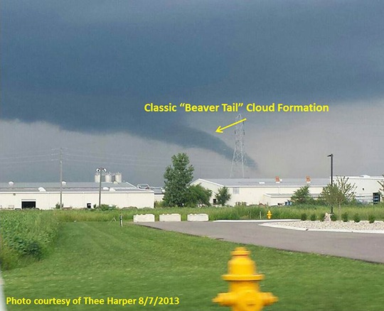
Photo of beaver tail cloud near Gosen
Photo of “beaver tail” cloud near Goshen, from NWS website.

As well-trained SKYWARN storm spotters know, “funnel cloud” has a specific definition in meteorology: It’s a rotating cloud that often exists before or after a tornado. Not every funnel-shaped cloud is a funnel cloud and not every rotating funnel cloud becomes a tornado.

Unfortunately for those in charge of Goshen’s tornado sirens, the cloud that appeared near Goshen was not a rotating funnel cloud and the city was not in danger of a tornado.

National Weather Service (NWS) meteorologists later confirmed that the cloud was a formation known colloquially as a “beaver tail,” which is formed as air cools while being sucked into a thunderstorm, thus allowing water vapor in that air to condense into a cloud. These clouds are normally mostly horizontal. When viewed from a certain angle, however, they can appear to be reaching toward the ground. The northern Indiana NWS office posted an excellent explanation on its website. Their article includes a helpful pair of photos of the same beaver tail taken from two different locations, demonstrating the illusion that can occur.

So, how are people supposed to know the difference? A true funnel cloud rotates. A beaver tail doesn’t. “If it doesn’t spin, don’t call it in,” is a mnemonic I learned in spotter training.

Members of the general public who have never taken SKYWARN training have little way of knowing this. So what’s a public safety agency to do when it gets reports of a funnel cloud from the general public? Here’s my opinion:

  1. Train public safety dispatchers to be aware that some funnel-shaped clouds that might prompt citizens to call 911 are not actual funnel clouds and therefore represent no danger to the community. This knowledge will help dispatches treat funnel cloud reports with a healthy amount of skepticism.
  2. Before sounding tornado sirens, seek confirmation from trained field personnel (e.g. nearby fire fighters, law enforcement officers, EMA volunteers and/or others known to have received SKYWARN training).
  3. Before sounding tornado sirens, place a quick call to the NWS. Ask if atmospheric conditions are right for the formation of tornadoes and whether NWS radar indicates any sign of rotation where the funnel cloud was reported. The NWS office can also tell the local public safety agency whether the NWS office has received any reports from trained spotters that would confirm or contradict public funnel cloud reports.

At the very least, any time a local public safety agency activates tornado sirens on its own (e.g. without an NWS warning), that agency should immediately notify the NWS that it has done so, and why. Why? Because without that notification, nobody who depends on NOAA weather radio or broadcast media for their warnings will know what’s going on!

Not everyone can hear tornado sirens where they live and work. Activating tornado sirens without contacting NWS to activate the entire warning system fails to protect those citizens who are beyond the range of sirens.

What do you think? Please add your comments below. And by the way, please understand that this post represents my personal view, not necessarily the views of any agency or organization.
NWS received delayed info on Peru tornado

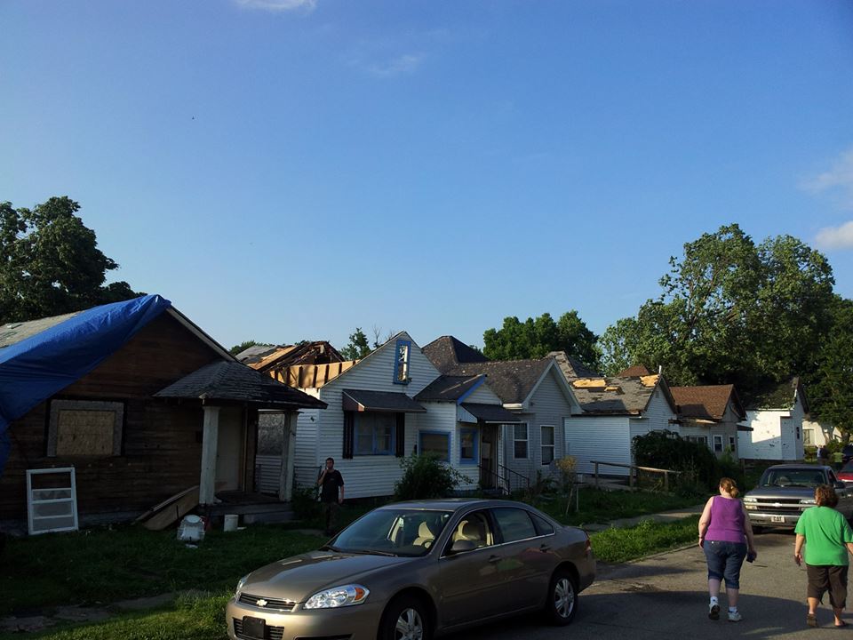
Peru, Indiana homes damaged by July 10, 2013 tornado. Emergency management agency photo from NWS Facebook page.

By guest blogger Michael Lewis, Warning Coordination Meteorologist, National Weather Service, Northern Indiana office

The National Weather Service (NWS) northern Indiana office received delayed reports of storm damage when an EF-1 tornado hit Peru, Indiana July 10. The northern Indiana office is located near North Webster and is responsible for issuing warnings for all of Miami County (of which Peru is county seat). The same office issues warnings for neighboring Wabash and Grant Counties. (See a map of all counties warned by the northern Indiana office.)

It is fortunate that the Peru tornado lasted for only five minutes and 3.5 miles. The absence of first-hand damage reports affected the warning process; requiring National Weather Service forecasters to rely on radar data and limited surface-based meteorological conditions as they issued subsequent warnings. In other words, the lack of timely and credible damage reports made the warning process more challenging. Had reports of damage been received closer to the actual time of occurrence, forecasters would have been able to refocus on other meteorological and radar data, and changed the message and content of the subsequent impact-based warnings.

As the storms continued to organize, strengthen and move east, the Northern Indiana NWS office searched for details of damage in the warned areas. This included searching numerous social media sites, making phone calls and listening to police and fire radio transmissions. The office continued to issue warnings as it gathered reports of wind damage, torrential rainfall and large hail.

Shortly after 3:11 p.m., a Facebook post indicated that damage had occurred in Peru but it didn’t provide complete details.
 
The NWS office received its first reliable information of the situation in Peru at 3:57 p.m., nearly two and a half hours after the tornado struck! At that time, a media partner forwarded a message that an Indianapolis journalist had posted in an Internet chat room devoted to the Indianapolis NWS office. The Indianapolis journalist relayed a report of extensive damage that he received from Kris Marks, the Miami County Emergency Management Agency director.

NWS northern Indiana office meteorologists surveyed the damage in Peru the day after the storm. During that survey, several local officials stated that reports of damage had been forwarded to news media in Indianapolis — not the National Weather Service. During the discussion with several other residents who witnessed the damaging storm, the common statement was that they rely on Indianapolis media because “that’s where they get their weather from.”

Public safety officials and the media in every community need to understand how the weather alert system works. They need to understand that reliable reports of storm damage must be forwarded to the appropriate NWS office as soon as possible.

These reports are critical to a successful warning process. While the damage was already done in Peru, such damage reports critically affect warnings for the next township, community and county over. While the Indianapolis news media broadcasts warning information, official tornado and severe thunderstorm warnings for Miami County and many other counties in the same area originate from the National Weather Service office in northern Indiana. The media cannot issue warnings that trigger the NOAA Weather Radio and Emergency Alert Systems. Any delay in reporting damage to the NWS can therefore significantly affect public safety.

Fortunately in this event, warnings were issued and the event occurred during daylight hours; no lives were lost.  It is critical to understand that the next time we may not be as fortunate.

Failure by local officials to relay reports to the appropriate NWS office hinders the NWS’ ability to issue warnings and prevents the NWS from fulfilling it’s mission of saving lives.


My thanks to Michael Lewis for this first-hand perspective of the issue. -W9LW

Tornado confirmed near Peru, Indiana

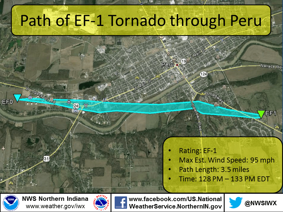
Map showing path of July 10, 2013 Peru, Indiana tornado

A National Weather Service damage survey team confirmed today that an EF-1 tornado touched down near Peru, Indiana July 10. Meteorologists estimate that the twister contained 95 mph winds. It was on the ground for 3.5 miles and lasted only five minutes. See photographs of some of the damage.

The tornado touched down at 1:28 p.m. NWS had not issued tornado warning. The tornado was probably too small to be detected by Doppler radar. NWS did, however, issue a severe thunderstorm warning for the same area at 1:19 p.m., nine minutes before the tornado touched down. NWS had issued a severe thunderstorm watch that included Miami County at 12:35 p.m., 53 minutes for the tornado touched down.

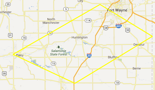
Map showing coverage area of 1:19 p.m. severe thunderstorm warning
Thunderstorm warning issued at 1:19 p.m. Covered the area within yellow outline.

The moral to this story: Do not ignore severe thunderstorm warnings! Severe thunderstorms can and do produce tornadoes quickly. Plus, even without a tornado, a severe thunderstorm can do as much damage as a weak tornado.

P.S. Thanks to the Iowa Environmental Mesonet website for making it easy to research previous-day warnings, etc.

Are Ham Radio SKYWARN Spotters Becoming Irrelevant?


Are ham radio SKYWARN spotters becoming irrelevant, the way that ubiquitous cell phones reduced the importance of repeater autopatches? Comments at a recent meeting hosted by the Northern Indiana National Weather Service could lead one to believe that answer is, “Perhaps.”
The Northern Indiana NWS weather forecast office conducted a workshop October 17 for its Integrated Warning Team (IWT). By NWS definition, an IWT includes the local NWS office, news media and emergency management community. The purpose of the workshop was to find ways to increase data sharing between the three components of the IWT. Representatives of each of the three IWT segments gave presentations on their needs. The comments of the NWS representatives were particularly interesting.
“The only way we really know what’s going on is when we get that ground truth report,” said an NWS presenter. Unfortunately, the NWS is not receiving enough timely reports from its trained spotters. An NWS representative expressed frustration at seeing significant radar data in an area where he knew trained spotters lived but getting no reports.
When reports don’t arrive via traditional means (like ham radio, or messages from emergency officials), the NWS has no choice but to search elsewhere for information. It has started searching on social media networks like Facebook and especially Twitter. It turns out that users of social media often write about the weather they see, because they believe their friends and followers are interested. Members of the IWT acknowledged that most such reports come from people without any weather training. But many social media users send their updates from camera-equipped smart phones and include photos with their reports.
“One picture of a funnel cloud is better than 10 reports from trained spotters,” an NWS representative said.
Does that mean ham radio operators should abandon SKYWARN nets? Perhaps not. But it might be wise to take steps to improve the value of our service. Here are some ideas to consider:

  • Education. By learning all we can about meteorology, we can assure that all our reports are valid and valuable.
  • Technology. By becoming familiar with and using other technologies to supplement ham radio (e.g. tweeting photos from smart phones), we can provide a more complete service while demonstrating our ability to stay on the “cutting edge.”
  • Procedures. By insisting on sounding as professional as possible when we communicate, we can build credibility among any IWT members who monitor or receive our reports.

In upcoming articles, I’ll share more ideas along these lines, especially ways to gain more education and use technology.