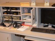
Restrictions implemented to slow the spread of COVID-19 will affect one of the ways SKYWARN® storm spotters send reports to local National Weather Service (NWS) offices. Many NWS weather forecast offices (WFOs) have amateur (ham) radio equipment permanently installed. During severe weather events, volunteer ham radio operators operate that equipment to receive reports of tornadoes and other dangerous weather from fellow hams who are storm spotters.
Now, however, the NWS is forbidding anyone not directly connected with the agency from entering WFOs, according to NWS Northern Indiana warning coordination meteorologist Michael Lewis. That means that ham radio stations at WFOs are less likely to be on the air during severe weather events. Some NWS meteorologists have ham radio licenses and some of those might be able to sporadically operate WFO ham stations. But Lewis told me that to reduce exposure to disease, the NWS is trying to operate WFOs with as few people in the office as possible. This might mean that NWS meteorologists who have ham licenses will have no time to operate the ham radio equipment.
Ham radio operators will still be able to use their radios to report severe weather, but they’ll need someone other hams to relay those reports to their local WFOs. That’s where an internal NWS text chat system will be essential, Lewis said. The system is called NWSChat and access is limited a select population. That groups includes ham radio operators who serve as net control station operators. Local ham radio SKYWARN groups can (and should) designate such leaders to serve as liaisons between the radio networks and NWSChat.
Whether or not spotters have ham radio licenses, other ways to communicate reports continue to be available, including telephone calls to WFOs and Twitter tweets that include the appropriate WFO’s Twitter handle.
The voice communication app Zello can also be helpful to SKYWARN storm spotters. Unfortunately, Zello’s terms and conditions do not comply with federal government requirements, so NWS WFOs are prohibited from installing Zello on any government-owned devices. A specific Zello channel exists (“IWX SKYWARN”) for reports from areas covered by the Northern Indiana office. Because WFO staff are prohibited from using Zello, ham radio net control station operators, who have NWSChat accounts, plan to monitor the Zello channel as much as possible, to relay reports from spotters to the WFO.
All this could be tested tomorrow, March 19, when severe weather is forecast in much of Indiana.
Library expands meeting space to accommodate
weather enthusiasts
Strong pre-registrations for a free class on how to recognize and report severe weather phenomena led a local organization to add meeting space to accommodate more people. The Allen County branch of the national Amateur Radio Emergency Service® (ARES) will host the class at the Allen County Public Library, 900 Library Plaza, Fort Wayne, Thursday, Feb. 21 at 6:30 p.m. By Feb. 12, only nine seats were still available, so the library agreed to expand the meeting space, adding 30 seats.
Scheduled speakers include meteorologists from ABC21, Fort
Wayne’s NBC, Fox 55 and WANE 15. Allen County Office of Homeland Security
director Bernie Beier and Consolidated Communications Partnership deputy
director John Chavez also plan to speak.
“This two-hour class will provide attendees the knowledge
they need to help protect their communities from severe weather like
tornadoes,” said Jim Moehring, emergency coordinator (team leader), Allen County
ARES. “Although we are a ham radio organization, people need not be hams to be
storm spotters, so we welcome anyone who is interested in weather.”
Moehring said the “ground truth” that volunteer spotters
provide is essential to the process through which the National Weather Service (NWS)
issues storm warnings. He pointed out that this remains true despite advances
in weather radar, because the beam from the NWS radar site near North Webster
is 2,500 feet or more above the ground by the time it reaches Allen County.
Traditionally, meteorologists from the NWS Northern Indiana
office near North Webster have presented spotter training every spring in Fort
Wayne. Changes in the office’s responsibilities, however, led it to change its
training schedule. As a result, NWS meteorologists won’t be in Fort Wayne until
autumn of 2019 and then not again until spring of 2021.
“We wanted to assure that our members and members of the
general public have a chance to receive storm spotter education before this
spring’s severe weather season,” Moehring said. “We therefore decided to devote
our group’s February meeting to a spotter class and to invite everyone to
attend. Because NWS meteorologists aren’t available, we’re thrilled that four
TV stations in Fort Wayne are sending meteorologists to help teach the
weather-related material.”
A complete list of speakers and their topics follows:
Jim
Moehring, Allen County ARES emergency coordinator (team leader):
Introduction to the NWS SKYWARN program and the importance of volunteer storm
spotters.
Jay
Farlow, Allen County ARES assistant emergency coordinator for SKYWARN: How
storm warnings are issued and distributed. Also, storm spotter reporting
methods and best practices.
Charles
Ward, experienced storm spotter: Best practices to remain safe while storm
spotting.
Bernie
Beier, Allen County Office of Homeland Security director: The role of the Allen
County Office of Homeland Security with regard to severe weather.
John
Chavez, Consolidated Communications Partnership deputy director: The role
of the Consolidated Communication Partnership (911/dispatch) in severe weather
events.
Caleb
Saylor, Fox 55 weekend meteorologist: Thunderstorm basics, including how
storms form and become severe.
Caleb
Chevalier, ABC21 weekend morning meteorologist: Types of thunderstorms,
including those most likely to create tornadoes. Also, radar apps and
interpretation.
Jon
Wilson, Fort Wayne’s NBC weekend meteorologist: Thunderstorm hazards,
including straight-line winds, large hail, flash flooding and tornadoes.
Nicholas
Ferreri, WANE 15 chief meteorologist: Cloud identification, including
distinguishing scary-looking but benign weather from true threats that spotters
should report.
About the Amateur
Radio Emergency Service
The Amateur Radio Emergency Service® (ARES) is a program of ARRL,
the national association for amateur radio®. ARES establishes teams of
volunteer, licensed amateur (ham) radio operators in counties throughout the
country, each of which is led by an emergency coordinator. These volunteer teams
train and practice to provide communication services to their communities in
the event of a disaster. Through a memorandum of understanding signed by ARRL
and the National Weather Service (NWS), ARES volunteers also commit to
communicating weather information that assists the NWS in the creation of
weather warnings. In addition, ARES volunteers practice their communication
skills by providing two-way radio communications at public events, such as
marathons, walk-a-thons, etc. More information about ARES is available on the
ARRL website at http://www.arrl.org/ares.
This blog’s author, Jay Farlow, W9LW, joining the WeatherBrains podcast Jan. 7, 2019, via Google Hangouts from his office/radio shack at home in Fort Wayne, Indiana.
A popular, weather-related podcast recently recorded an episode devoted to the role of amateur (ham) radio in the weather enterprise, especially storm spotting. WeatherBrains is a long-running, well-respected podcast hosted by Alabama broadcast meteorologist James Spann. It recorded the ham radio podcast January 7.
Ham radio has been deeply involved in the National Weather Service’s (NWS) SKYWARN® program since its inception, according to research done by Brian E. Smith, the warning coordination meteorologist at the NWS Omaha/Valley weather forecast office (WFO) in Nebraska. During the infamous Palm Sunday tornado outbreak of 1965, a tornado did F4 damage in northern Toledo, Ohio. Afterward, a ham who was also a meteorologist in the Toledo office of what was then called the U.S. Weather Bureau — Merle Kachenmeister, WA8EWW — organized ham radio operators in his area to report severe weather to the Toledo office via radio. This is considered the birth of the SKYWARN program, according to Smith.
WeatherBrains episode number 677 is available for viewing or listening on the the podcast’s website. Listeners can also access the audio-only version on their mobile devices via their favorite podcast apps.
The author of this blog was one of the guests who WeatherBrains invited to discuss ham radio. Other guests included Jeff Stapel, W8SWX of the Muskegon, Michigan SKYWARN organization and Rob Macedo, KD1CY, who is both the Section Emergency Coordinator of the ARRL Eastern Massachusetts section and director of operations for the VOIP Hurricane Net.
During the show, I mentioned several resources that might be valuable to audience members. For your convenience, I’ve listed them below:
The tornado outbreak of Aug. 24, 2016: This page on the website of the NWS northern Indiana WFO includes the radar rotation tracks I showed during the podcast, as well as other information about how the outbreak affected my home area.
ARRL Ham Radio License Manual: This book contains all the information you need to pass the exam and get your ham radio license, so you can join other storm spotters on the air.
Storm Spotting and Amateur Radio: This book is a valuable resource for anyone who is interested in either storm spotting or how to use ham radio while spotting. It includes information on resources, training, equipment, safety, storm spotter activation procedures and more.
Allen County (Ind.) SKYWARN Net Operations Manual: This PDF document discusses in great detail how the hams of the Fort Wayne and Allen County, Indiana area organize their SKYWARN net — i.e. on-air conference call — during severe weather events.
A couple resources I didn’t have time to get into regard equipment (although Rob mentioned some price ranges). Below are links to some equipment options you might consider, if you’re thinking about getting into ham radio:
Baofeng UV-5R handheld radio: Available on Amazon for only $25, this will get you on the air. Like any handheld radio, its geographical range is limited, but as long as you’re close enough to what hams call a “repeater” station, you can talk to people dozens of miles away.
AnyTone AT-778UV Mobile radio: Available on Amazon for $130, this radio mounts in your vehicle and connects to your vehicle’s 12-volt poser source. It transmits with 25 watts, versus the 5 watts of most handheld radios, enabling you to communicate while farther from the repeater station. It requires an external antenna, sold separately. Antenna options include those with temporary magnetic mounts and those that can mount more permanently on a trunk lid without drilling holes.
The “big three” brands of ham radio equipment are Icom, Kenwood and Yaesu. Their radios, while well respected, tend to be priced higher on the new market than the Chinese brands above. Note, however, that there’s a large market for pre-owned radios. These can be obtained through some dealers (who take trade-ins), at ham radio flea markets and through online auction sites.
Anyone can help protect their community from weather threats like tornadoes. In just a couple of hours, you can learn how severe weather forms, how to distinguish truly threatening weather from scary-looking but harmless clouds, and how to report severe weather so the rest of your community can be adequately warned.
The Allen County chapter of the Amateur Radio Emergency Service (ARES) invites all interested persons to attend its Feb. 21 meeting, from 6:30 to 8:30 p.m., at the main, downtown branch of the Allen County Public Library, The meeting will be devoted to severe weather and storm spotting. You don’t have to be a ham radio operator and you don’t need any prior knowledge of meteorology or communications.
Scheduled speakers include ABC21 Weekend Morning Meteorologist Caleb Chevalier, WANE 15 Chief Meteorologist Nicholas Ferreri, FOX 55 weekend Meteorologist Caleb Saylor, Fort Wayne’s NBC Weekend Meteorologist Jon Wilson, Allen County Office of Homeland Security director Bernie Beier, Consolidated Communications Partnership (911/public safety dispatch) director David Bubb, Allen County ARES team leader Jim Moehring and Allen County SKYWARN ham radio net manager Jay Farlow.
Although representatives of the National Weather Service (NWS) are not available for this meeting, we will follow the NWS SKYWARN curriculum with enhancements specific to Allen County. NWS does not plan to teach a spotter class in Allen County until autumn of 2019.
This meeting will be valuable to anyone who is interested in severe weather, including those who have previously received storm spotter training. More information is available on the host’s Facebook page.
Tonight, I was the guest speaker at a meeting of the Allen County Amateur Radio Technical Society on the topic in the title above. I promised the members present that they would not have to write down all the web URL’s I mentioned, because i’d post them here. Each item in the bulleted list below links directly to the respective online resource.
I can’t count the number of times I’ve gone out of my way to make sure people know I’m not a storm chaser. I’ll very likely stop doing that, however, in part because of something I heard renowned tornado researcher Dr. Chuck Doswell say this week on a podcast.
It’s well known that the behaviors of some storm chasers have created a negative image of the hobby. We frequently see stories of chasers taking risks that we might consider unacceptable, driving recklessly and/or causing traffic problems. It’s this negative image that made me want to distance myself from the chaser community.
This week, however, Doswell posited that there’s real value in storm chasing, even for (perhaps especially for) storm spotters.
“I’ve never had a problem with spotters who want to be chasers. In fact, I think it’s a great idea,” Doswell said on episode 635 of “WeatherBrains,” the weather podcast hosted by Alabama television meteorologist James Spann.
“Every time I go out (as a chaser), I see something I’ve never seen before,” Doswell continued. “If you’re just an ‘ordinary spotter,’ the number of storms that you would see in any given year is fairly small, unless it’s just a fantastically busy year in your neighborhood that year. But, as a chaser, you can sample more storms. If I’m out for two weeks, I’ll probably see 20, 30 different storms. And of those, maybe some fraction will be supercells and some fraction of those will produce tornadoes. But every year, then, I see a fairly large sample of storms. So, I’ve been doing this for more than 45 years, and so I’ve seen a lot of storms, and I’m still seeing things that I’ve never seen before.”
“So, chasing and spotting are not necessarily opposed to one another,” Doswell added. “I would recommend anyone who’s a serious spotter to go ahead and chase, if for no other reason than to expand their vocabulary of storms.”
WeatherBrains panelist Rick Smith, who works as warning coordination meteorologist at the National Weather Service office in Norman, Oklahoma, agreed. “The best spotters, I think, are the ones that are kind of the hybrid chasers and spotters.”
Doswell and Smith make an interesting point. There’s only so much a storm spotter can learn by looking at photos and video. Seeing the real thing in person would logically make it easier for a spotter to later recognize important storm features as a storm approaches the spotter’s home jurisdiction.
So, I hereby discontinue my previous efforts to distinguish myself from storm chasers. In fact, I’m seriously thinking about asking one of the accomplished chasers I know if I can go along on a chase sometime. Heck, if I ever have the spare cash, I might even buy a seat on a well-regarded storm chasing tour, like those offered by Tempest Tours (some of which Doswell himself leads) or the College of DuPage (which allows anyone to easily register as a student for that single class).
One thing you won’t see me doing is trying it on my own. Numerous experts in the field extolled the dangers of solo chasing, as did Dr. David Call of Ball State University during the recent Central Indiana Severe Weather Symposium in Indianapolis.
But perhaps in the future, you’ll hear me saying, “I’m a storm spotter and sometimes a chaser,” rather than the statement in the title of this blog post.
For some time, I’ve looked at amateur storm chasers with some disdain. I believed that too many were putting themselves into too much danger, just to see, photograph and/or video record tornados. I doubted that many chasers were truly motivated by improving public safety and even fewer were doing real science, no matter what they said. I was concerned that many chasers set poor examples for the general public and that their “antics” encouraged lesser informed people to take uneducated and unwise risks.
I’ve been a SKYWARN storm spotter for more than a quarter century. When talking to friends, family members and even journalists about my volunteer service to the National Weather Service (NWS), I was careful to make sure they understood that I’m not a chaser, like the people they’ve seen on TV or on the Web. My ultimate goal, I’d explain, isn’t to see tornadoes, it’s to help protect my community from possible storms by staying close to home and relaying valuable information to the NWS.
So it was with some trepidation that I attended an event in November, 2015 called INChaserCon, a one-day convention in the Indianapolis area for storm chasers. I’m glad I went. Some of the people I met there changed my thinking. They are admittedly driven by a desire to see tornadoes. But my experience with them demonstrated that they’re also very passionate about getting reports to the NWS.
After the chasers learned that I have access to NWSChat – a private, internet-based text chatroom run by the NWS – they invited me to join them on Zello, a smartphone app with which they communicate with each other—so I could relay their reports to the NWS via NWSChat.
That’s exactly what happened during the August, 2016 tornado outbreak in Indiana and Ohio. As a tornadic storm moved east from Kokomo into the county warning area of my local NWS office, storm chasers John Tinney, Eric Lawson and David Buell reported wall clouds, funnel clouds, etc. via Zello. I relayed those reports via NWSChat.
Then, a storm over my own home in Fort Wayne, Indiana received a tornado warning. Storm chaser Michael Enfield immediately headed toward that storm. Via Zello, he promptly reported a wall cloud, then funnel clouds and then a tornado for me to relay via NWSChat. The NWS survey report recorded the time of the tornado’s initial touchdown as 5:27 p.m. – the same time as Enfield’s report, confirming that he saw and reported the tornado when it first touched down. That storm eventually did EF-3 damage to a rural part of Allen County, Indiana.
Throughout the event, any time the chasers had something to report, if I wasn’t immediately available on Zello, they’d keep trying until I acknowledged their reports. Getting reports through to the NWS was clearly very important to them. By the end of the event, I had typed 50 reports into NWSchat. All but about 15 of those came from storm chasers on Zello. The rest came from storm spotters via ham radio.
By aggressively chasing storms, my new friends put themselves in positions to immediately report weather that was not near any traditional SKYWARN spotters at the time. By religiously reporting, they played significant roles in protecting people in the paths of the storms.
A Facebook post by Lawson sums up pretty well how this particular group of storm chasers sees things:
“I noticed a developing supercell heading towards Kokomo was looking really strong and rushed out the door. By the time I was on interstate 69 southbound the strong EF3 was already in progress and heading towards the town in which I have spent many days of my youth, and is home to many great friends and their families. Hearing reports of the devastation in progress on the radio made my heart sink. I was rushing south in horror wondering if anyone I knew had been hurt. This is the moment that things really changed for me, I felt less excited about seeing tornadoes, and much more concerned with providing accurate information to keep people informed.”
I have no doubt there are other storm chasers out there who rarely report their observations to the NWS. There are likely some that don’t care about anything but the excitement of seeing a tornado.
But I’m convinced that the storm chasers I know are not among these. They’ve changed my attitude about chasers.
The DuPage County (Illinois) Office of Homeland Security and Emergency Management hosts an annual severe weather seminar in Chicago’s western suburbs to provide advanced training to SKYWARN storm spotters. This year’s 25th-annual event was March 12 at Wheaton College and was attended by approximately 500 people. Here are a few tidbits that I took from the seminar.
Spotters continue to be essential
“A dead spotter does no good for anybody,” said National Weather Service (NWS) Storm Prediction Center lead forecaster Roger Edwards. He reassured spotters that they continue to be important, even in this high-tech age, but that it’s better to miss seeing something than to risk getting hurt.
Edwards suggested that spotters plan spotting locations in advance, so they’ll know where to go for the best safety as well as the best views. He also provided a list of questions spotters should ask themselves on a severe weather day, such as what types of storms to expect, how to expect them to move, etc.
A slide from a presentation SPC lead forecaster Roger Edwards provided during the 2016 DuPage County Advanced Severe Weather Seminar
Edwards instructed spotters that if they can hear a tornado, it’s too close and they should be in shelter. He also pointed out that even the inflow from a big tornado can damage or roll a vehicle.
Spotters can help protect others by sharing preparedness info
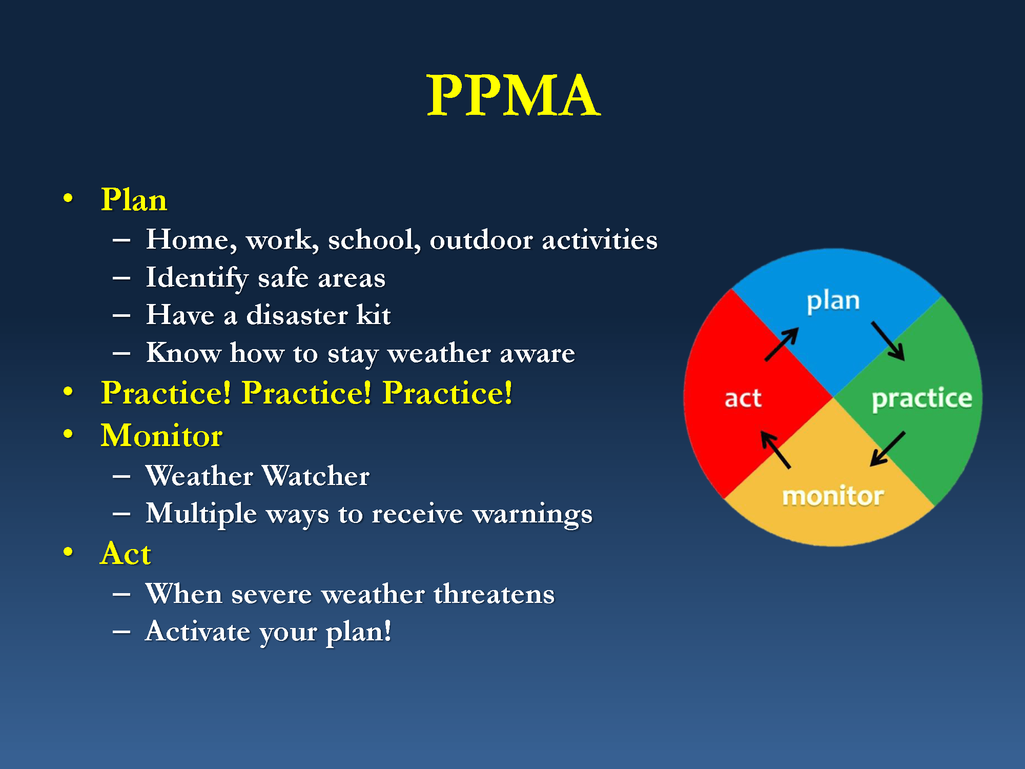
Warning coordination meteorologist Mike Bardou of the Chicago NWS office spoke about severe weather preparedness. He described a preparedness framework based on four verbs: Plan, Practice, Monitor and Act.
A slide from a presentation that NWS meteorologist Mike Bardou provided at the 2016 DuPage County Severe Weather Seminar: Plan, Practice, Monitor, Act.
He encouraged spotters to spread the word and help others prepare, especially employers, fellow employees, families, neighbors and friends. As I have written in this blog, it’s often the case that such people don’t know anyone else who knows as much about weather as do spotters. If spotters are passionate enough about weather safety to spend hours watching storms, they should be equally motivated to help others learn how to protect themselves from severe weather. That, in fact, is one of the main reasons I created this blog.
Busy interstate highways are a major concern
During a presentation on storm structure, NWS Chicago meteorologist Ben Deubelbeiss spoke on the danger of getting trapped by a tornado on a busy interstate highway. Imagine what any of Chicagoland’s busy interstates would be like if a tornado hit it during the afternoon rush hour! Deubelbeiss said many people have no idea what to do in that situation. He reminded the audience that crouching under an overpass is the worst thing to do, because the Venturi effect increases the speed of the wind as it blows through. This often leaves no option but to get as low as possible in a ditch while remaining mindful of the possibility of a flash flood during a high-precipitation storm.
Deubelbeiss encouraged spotters to always call in reports, even if the NWS has already issued warnings for the area. The NWS might have no other way to know about the tornado or other phenomena spotters see.
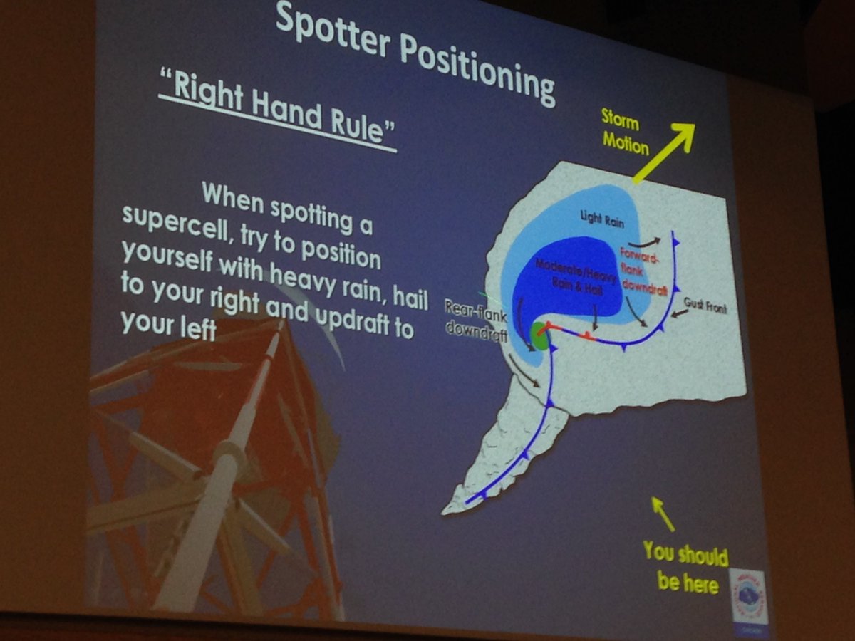
A slide from a presentation that NWS meteorologist Ben Deubelbeiss provided during the 2016 DuPage County Advanced Severe Weather Seminar depicting the “right-hand” rule for spotting supercell thunderstorms.
And when spotting typical supercells, Deubelbeiss reminded spotters that they should follow the “right-hand rule”; positioning themselves with the storm’s heavy rain and hail to their right and updraft to the left.
Time-lapse storm photography aids education
College of DuPage meteorology professor Victor Gensini demonstrated how time-lapse photography of storms facilitates identifying features. Here’s an example:
Gensini uses a digital SLR but he said that even a smartphone on a cheap tripod can suffice.
Gensini also spoke about his recently published research on forecasting tornado activity weeks in advance. A recent interview of Gensini in “Forbes” provides a good explanation.
The U.S. National Weather Service has been issuing tornado and severe thunderstorm watches and warnings since 1965. More than 50 years later, however, people still fail to fully understand the difference between a watch and a warning. You probably know some of them, I certainly do.
Map showing tornado watch for a large part of Indiana and Michigan for 11:20 a.m. to 8 p.m. Nov. 17, 2013.
In fact, before 1965, the NWS called what we now know as “tornado watches” “tornado forecasts.” A tornado watch indicates the possibility of tornadoes forming, just as a rain forecast indicates the probability of rain. Similarly, a severe thunderstorm watch indicates the possibility of severe thunderstorms forming. A watch does not mean these things are already happening, it means they could happen.
Like a forecast, a watch covers a period of many hours and usually covers a large area of at least several counties, if not several states. We should watch for possible dangerous weather in the near future.
A warning is an indication of immediate danger
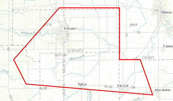
Polygon indicating the area covered by a tornado warning for the Kokomo, Indiana area from 3:17 p.m. to 3:45 p.m. Nov. 17, 2013. Click the image to see a larger version.
It’s a call to take shelter now, because the tornado or severe thunderstorm is already happening. Depending on where you are, you might only have couple of minutes to protect yourself and your family. Or, you might have 10 or 15 minutes, if you’re at the far edge of the “warning polygon.” If you want to survive a tornado or a severe thunderstorm, don’t waste time seeking more information. When a warning comes out, take shelter immediately.
Because dangerous weather has already formed and is on its way, a warning usually covers a period of less than an hour and a small area that’s sometimes smaller than a county. The time to watch is over. It’s now time to heed the warning and take shelter.
Want even more lead time?
If you’re really interested in weather, or want to know even earlier whether severe weather is possible, there are two other NWS products to check out.
The NWS Storm Prediction Center (SPC) usually issues a “mesoscale discussion” before it issues a watch. This product lets you know that the SPC is thinking about (or planning to) issue a watch, the geographical area of concern and the reasons. Some of the text of a mesoscale discussion can get pretty technical, but anyone can figure out from this product whether a watch is likely to be issued. If any mesoscale discussions are in effect, you can find them on the SPC website.
For even more lead time, the SPC issues “convective outlooks” that indicate the amount of risk of severe weather as much as eight days in advance. You can also find these products on the SPC website.
County warning areas of each National Weather Service weather forecast office (NWS image).
During the Central Indiana Severe Weather Symposium, March 5, 2016 in Indianapolis, an attendee asked how spotters, particularly those who are hams, can report to appropriate National Weather Service (NWS) weather forecast offices (WFO) while traveling away from home.
There are several good answers to that question. It helps to know that each WFO has its own area of responsibility, which the NWS calls a county warning area (CWA). It is defined by a list of counties (or parishes) for which that WFO issues weather warnings. Generally speaking, every county in a given WFO’s CWA is closer to that WFO’s doppler radar station that to any other WFO’s radar. This is why CWAs often cross state lines.
If you want to make a spotter report while traveling, therefore, you need to know two things:
Which WFO’s CWA you’re in.
How to contact that WFO.
SpotterNetwork.org
SpotterNetwork.org’s reporting page displays the ID and phone number of the appropriate NWS office to members who are logged in and using a location-reporting app.
By far, the simplest way to accomplish both steps above is to register with SpotterNetwork.org and install compatible position-reporting software on a smartphone or similar GPS- and mobile- data-equipped mobile device.
In my case, RadarScope (when properly configured and activated) continually transmits my iPhone’s GPS coordinates to SpotterNetwork.org servers. If I need to make a report, I just log into my account on SpotterNetwork.org’s home page with any Web browser (including the one on my phone), and then select the “Submit Severe Report” link.
Because SpotterNetwork.org knows where I am, it displays at the top of the reporting page the three-letter identifier of the WFO whose CWA I’m in and the best telephone number through which to make a report to that WFO (in most cases, it’s the “bat phone” number that’s reserved for spotters). Then, I can call that number (the best choice for life-threatening situations, like a tornado) or enter my report into the SpotterNetwork.org website and let SpotterNetwork.org send it to the proper WFO electronically.
Weather.gov
The watch-warning-advisory map on the NWS home page allows viewers to find the NWS office for any location by clicking that location on the map.
You can determine the appropriate WFO for any location in the country by using the NWS home page, www.weather.gov. Just click anywhere on the U.S. map. Near the top of the Web page that appears, you’ll see a headline that indicates the name of the WFO in whose CWA you clicked. If you scroll to the bottom of that page, you’ll find a phone number for that WFO. Unfortunately, it’s the main office phone number, not the special spotter report number. Depending on the time of day and how the WFO set up its phone system, you might not be able to reach a WFO staff member on that number.
Once you get on the appropriate WFO’s website, however, you should be able to easily find a weather reporting Web form, the WFO’s Twitter handle or even a link to the WFO’s Facebook page, all of which provide alternatives to calling.
If you don’t have mobile Internet, you can use weather.gov before your trip to make your own list of the WFOs through whose CWAs your route will take you.
911
You can call 911 to report life-threatening weather. The phone system will automatically route your call to an appropriate public safety answering point (PSAP) for your location, where a staff member will know how to relay your report to the appropriate WFO.
Disadvantages of this method include:
During times of severe weather, PSAPs are often too busy taking incoming calls to relay any information to the NWS.
The PSAP call taker might not appreciate being told about one-inch-diameter hail, even though the WFO would want to know about it.
Amateur (ham) radio
Learning how to make spotter reports via ham radio while out of your normal area can be challenging. You’ll have to determine which frequency is used by hams in your current location. Even if you’re successful, you might not be able to reach the WFO or someone who can relay your report to the WFO.
In most communities, hams conduct weather-related communications on a repeater system. Ways to learn what repeaters exist in any location include the American Radio Relay League’s (ARRL) printed “Repeater Directory,” the website and apps of the ARRL-endorsed www.rfinder.net and the independent RepeaterBook.com website.
Some listings in the ARRL directory and on repeaterbook.com indicate that a listed repeater is used for weather-related activities. When that indication is available, such repeaters are good places for ham-radio-equipped spotters to start. You might, however, need to try multiple repeaters within range to find one on which a SKYWARN net operates. It’s therefore a good idea to communicate with local hams as you enter an area, so that you’ll already know about local on-air SKYWARN practices before you need to call in a report. This is especially important, because the local SKYWARN net might not permit participation by outsiders.
Call your home WFO
As a last resort, you can always use the “bat phone” number for your home WFO. Be sure to tell the call taker early in the call that you’re outside their CWA and that you’re requesting them to relay your report to the appropriate WFO.