Tag Archives: #INwx

Know anyone who’s still confused by watch vs. warning?

Wizard of Oz witch tornado watch warning meme
Meme creator unknown

The U.S. National Weather Service has been issuing tornado and severe thunderstorm watches and warnings since 1965. More than 50 years later, however, people still fail to fully understand the difference between a watch and a warning. You probably know some of them, I certainly do.

As my contribution to the second day of Indiana’s Severe Weather Preparedness Week 2016, I’ve written this blog to share with your friends and family members who remain confused.

A watch is essentially a forecast

Map showing tornado watch for a large part of Indiana and Michigan for 11:20 a.m. to 8 p.m. Nov. 17, 2013.

In fact, before 1965, the NWS called what we now know as “tornado watches” “tornado forecasts.” A tornado watch indicates the possibility of tornadoes forming, just as a rain forecast indicates the probability of rain. Similarly, a severe thunderstorm watch indicates the possibility of severe thunderstorms forming. A watch does not mean these things are already happening, it means they could happen.

Like a forecast, a watch covers a period of many hours and usually covers a large area of at least several counties, if not several states. We should watch for possible dangerous weather in the near future.

A warning is an indication of immediate danger
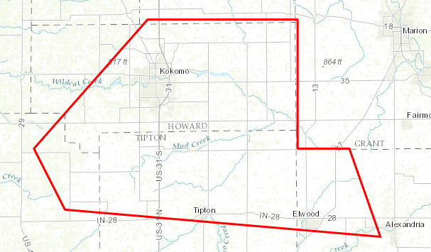
Polygon indicating the area covered by a tornado warning for the Kokomo, Indiana area Nov. 17, 2013.
Polygon indicating the area covered by a tornado warning for the Kokomo, Indiana area from 3:17 p.m. to 3:45 p.m. Nov. 17, 2013. Click the image to see a larger version.

It’s a call to take shelter now, because the tornado or severe thunderstorm is already happening. Depending on where you are, you might only have couple of minutes to protect yourself and your family. Or, you might have 10 or 15 minutes, if you’re at the far edge of the “warning polygon.” If you want to survive a tornado or a severe thunderstorm, don’t waste time seeking more information. When a warning comes out, take shelter immediately.

Because dangerous weather has already formed and is on its way, a warning usually covers a period of less than an hour and a small area that’s sometimes smaller than a county. The time to watch is over. It’s now time to heed the warning and take shelter.

Want even more lead time?

If you’re really interested in weather, or want to know even earlier whether severe weather is possible, there are two other NWS products to check out.

The NWS Storm Prediction Center (SPC) usually issues a “mesoscale discussion” before it issues a watch. This product lets you know that the SPC is thinking about (or planning to) issue a watch, the geographical area of concern and the reasons. Some of the text of a mesoscale discussion can get pretty technical, but anyone can figure out from this product whether a watch is likely to be issued. If any mesoscale discussions are in effect, you can find them on the SPC website.

For even more lead time, the SPC issues “convective outlooks” that indicate the amount of risk of severe weather as much as eight days in advance. You can also find these products on the SPC website.

Where thunderstorms go to die

SKYWARN storm spotters and future spotters prepare for training Feb. 16, 2016 at the Public Safety Academy of Northeast Indiana, Fort Wayne

The husband-and-wife team of Amos and Megan Dodson, both meteorologists at the northern Indiana office of the National Weather Service (NWS), conducted the annual SKYWARN storm spotter training Feb. 16 at the Public Safety Academy of Northeast Indiana.

The content of the training didn’t change much from last year’s presentation. It focused on the differences between truly threatening weather phenomena and scary-looking, but harmless (and unreportable) conditions.

Here are some highlights:

  • Spotter reports add credibility. When the NWS issues a warning that includes a reference to a spotter report, members of the general public are more likely to take action than when the warning does not include a spotter reference.
  • Don’t wait for activation. Although our NWS office issues hazardous weather outlooks that indicate whether spotter activation is likely, the office does not “activate” or “deploy” spotters. It welcomes spotters to make reports anytime they see anything reportable.
  • Clouds with ragged edges aren’t spinning. Scary-looking SCUD clouds that are shaped like funnel clouds generate a lot of well-intended but false reports from untrained observers. True funnel clouds and tornadoes spin, giving them sharper, smoother edges.
  • When unsure, send a photo. NWS encourages spotters who see something that might be reportable (like a possible wall cloud or funnel cloud), to photograph it and send the photo via Twitter (@NWSIWX) or the NWS office’s Facebook page. The office monitors both social networks closely during severe weather events.
  • T.E.L. NWS. When spotters make reports, they should provide the Time of the observation, a description of the Event, and the Location of the event. The actual time of day is more valuable than “right now” or “two minutes ago.” And because the local NWS office does not issue spotter credentials, formatting reports in that specific order is one way spotters can demonstrate they attended the training.
  • Thunderstorms come here to die! Spotters provide a valuable service to their communities even if they don’t see anything reportable. And climatology data shows that spotters in Indiana are about half as likely to see something as are spotters in Illinois. Megan Dodson shared that this leads meteorologists to joke that Indiana is where thunderstorms come to die.

Mysteriously, far fewer people attended the training than registered for it, even though weather did not hinder travel that night. Those in attendance, however, included TV meteorologist Hannah Strong, who indicated that the presentation included information not provided in meteorology school.

People who missed the training can get via the Web most of the information they need to be effective spotters. Two options include

A weather safety tip you might not have thought of: Footwear

Photo of feet wearing flip-flops with red X superimposed. Flip-flops are poor footwear for severe weather days. Indiana Severe Weather Preparedness Week. #INWxReady #WRNSandals, especially flip-flops, which are so popular when the weather is warm, are poor choices for severe weather days.

My feet get warm easily. I have a pair of Chacos brand sandals that I wear almost every day during warm weather. But not on days that I might need to serve as a storm spotter.

If severe weather is coming our way, I usually change into a sturdy pair of ankle-supporting hunting boots I bought on sale at Cabela’s, even if I’ll be staying home during the storm.

Why? On word: debris.

National Weather Service photo

After a storm passes, I might have to walk through storm debris, which can include pieces of trees and pieces of buildings. The walking surface might be uneven. Some of the debris might have sharp edges.

I choose to protect my feet from all that, a practice I learned back in the 90s when I served as an emergency medical technician and communications technician on a Disaster Medical Assistance Team. It’s how I dressed my feet every day, even in tropical weather when assisting the victims of Hurricanes Andrew and Marilyn.

My advice: If you’re a storm spotter or storm chaser, get yourself a good pair of boots to wear anytime you’re in the field, even on hot, humid days. And no matter who you are, if you ever have to take shelter in your house from a coming storm, take the most protective footwear you have with you to the basement, interior room, etc. Put them on after the storm, before you step outside to survey the damage. Your feet will be much safer.

Severe weather watches and warnings: Do you really know the difference?

Tornado graphic for Indiana Severe Weather Preparedness Week 2015Governor Mike Pence has proclaimed March 15 through 21, 2015 as Severe Weather Preparedness Week in Indiana.

Throughout the week, I’ll use my “W9LW’s Ramblings” blog to help build awareness of important severe weather concepts that everyone should know.

If you’re a trained storm spotter, you’ll already know most of the stuff I’ll write about. In that case, I encourage you to use Indiana Severe Weather Preparedness Week to share this information with your family, friends and co-workers. After all, you are probably the closest thing to a weather expert who those folks know personally.

Today, I’ll start with one of the most basic of severe weather concepts, but also one of the most important; knowing the difference between a severe weather watch and a warning.

The National Weather Service (NWS) has used the term, “watch,” since August of 1965 but I still talk to people who don’t really understand what a watch is and others who refer to watches as warnings and warnings as watches.

Here’s a simple table to help you remember the difference. The information below applies to both tornado and severe thunderstorm warnings and watches.

Warning Watch
Your response Take shelter now! Remain alert, determine where you’ll take shelter if necessary
Meaning Severe weather is imminent, has been detected by radar and/or confirmed by trained weather spotters Conditions are favorable for the development of severe weather in and close to the watch area
Timeframe Minutes before danger arrives Usually hours before severe weather occurs
Geography Very local, sometimes less than a county, based on storm location and track Regional, multiple counties, often crossing state lines, based on atmospheric conditions

Bottom line: When the NWS issues a warning, it’s time to take action. Now. When the NWS issues a watch, it’s time to make sure you’ll know about a warning if one comes out later and time to make sure you know what you’ll do if a warning comes out.

Please share this! Do you know someone who doesn’t really understand watches and warnings? Use the buttons below to share a link with your social networks, etc.