Editor’s Note: The Nashville, Tenn. National Weather Service office and other organizations hosted an annual “Severe Weather Awareness Day” at Trevecca Nazarene University Feb. 27, 2016. What follows is a guest post from Ken Helms, AB9ZD, who attended the event.
I enjoyed the Severe Weather Awareness Day 2016 in Nashville yesterday.
Spann
The keynote speaker was James Spann, chief meteorologist for ABC in Birmingham. He discussed the 2011 super outbreak that killed 252 people in Alabama and he focused on what happened, why people died, and what needs to be done differently. Among the reasons he gave for the high number of deaths:
Low income families didn’t get the warnings (can’t afford weather radios, smart phones, etc).
Each local station had its own way of categorizing the severity of a storm causing confusion.
Too many false alarms over the years so some people didn’t take the warning seriously (crying wolf).
Warnings by the news media were given by county and not localized enough for people to know if they were really at risk or not.
Many people didn’t have an effective place to shelter from a tornado (very few basements in southern houses).
Spann is a very passionate speaker on the subject.
There was also a panel discussion with five of the local TV stations’ meteorologists which was interesting.
Representatives from the NWS and the county EMA discussed area tornadoes including one that hit Gallatin (a city not far from Nashville) in 2006 that killed eight people.
Basic and advanced storm spotter training was included as well.
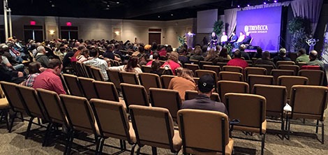
The event was held in a large room and was well attended. It was nearly standing-room-only for Spann’s presentation — there were no empty seats around me. Quite a few students were there. A group of meteorology majors from another Tennessee college sat in front of me. Attendance thinned out as the day went on.
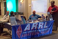
They had an area set up for representatives from the local TV stations, colleges, and the NWS outside the conference room. Most were handing out brochures along with things like pens, pencils, ice scrapers, and stickers. The American Radio Relay League (ARRL) had a table as well.
SKYWARN storm spotters and future spotters prepare for training Feb. 16, 2016 at the Public Safety Academy of Northeast Indiana, Fort Wayne
The husband-and-wife team of Amos and Megan Dodson, both meteorologists at the northern Indiana office of the National Weather Service (NWS), conducted the annual SKYWARN storm spotter training Feb. 16 at the Public Safety Academy of Northeast Indiana.
The content of the training didn’t change much from last year’s presentation. It focused on the differences between truly threatening weather phenomena and scary-looking, but harmless (and unreportable) conditions.
Here are some highlights:
Spotter reports add credibility. When the NWS issues a warning that includes a reference to a spotter report, members of the general public are more likely to take action than when the warning does not include a spotter reference.
Don’t wait for activation. Although our NWS office issues hazardous weather outlooks that indicate whether spotter activation is likely, the office does not “activate” or “deploy” spotters. It welcomes spotters to make reports anytime they see anything reportable.
Clouds with ragged edges aren’t spinning. Scary-looking SCUD clouds that are shaped like funnel clouds generate a lot of well-intended but false reports from untrained observers. True funnel clouds and tornadoes spin, giving them sharper, smoother edges.
When unsure, send a photo. NWS encourages spotters who see something that might be reportable (like a possible wall cloud or funnel cloud), to photograph it and send the photo via Twitter (@NWSIWX) or the NWS office’s Facebook page. The office monitors both social networks closely during severe weather events.
T.E.L. NWS. When spotters make reports, they should provide the Time of the observation, a description of the Event, and the Location of the event. The actual time of day is more valuable than “right now” or “two minutes ago.” And because the local NWS office does not issue spotter credentials, formatting reports in that specific order is one way spotters can demonstrate they attended the training.
Thunderstorms come here to die! Spotters provide a valuable service to their communities even if they don’t see anything reportable. And climatology data shows that spotters in Indiana are about half as likely to see something as are spotters in Illinois. Megan Dodson shared that this leads meteorologists to joke that Indiana is where thunderstorms come to die.
Mysteriously, far fewer people attended the training than registered for it, even though weather did not hinder travel that night. Those in attendance, however, included TV meteorologist Hannah Strong, who indicated that the presentation included information not provided in meteorology school.
People who missed the training can get via the Web most of the information they need to be effective spotters. Two options include
Dunkirk volunteer storm spotter Gary Wesley paid a sign company to decorate his primary vehicle with weather-related graphics to promote his avocation.
An east-central Indiana man has gone to unusual lengths to promote the National Weather Service’s SKYWARN program, which recruits and trains volunteer storm spotters. Gary Wesley, Dunkirk, bought a decommissioned, 2005 Chevrolet Impala police car and paid a sign company $2,000 to design, create and wrap the vehicle with weather-related graphics. Wesley also installed an amber light bar and ham radio antennas.
Having gotten involved in storm spotting as a teen, Wesley was disappointed by the level of interest he discovered when he settled in Dunkirk after a medical retirement from a military career that included time as a recruiter for the Indiana Army National Guard. His work as a recruiter gave him an idea to promote the SKYWARN program.
“We had a Humvee that we called, ‘The Super Hummer,’ that was all decked out with images on it to help with recruiting at events,” Wesley said.
He decided to create his own rolling billboard for storm spotting.
“I figured, with my passion for being involved in storm spotting and volunteer work, it would just be an easy way to promote it,” Wesley explained. He believed that if nothing else, people who saw the car would ask questions about it, giving him a chance to talk about storm spotting.
Wesley uses the car for more than storm spotting. It’s one of two cars in the family (his wife drives a Jeep) and his primary form of transportation.
“The only thing that I’m hoping for … is to be able to increase the number of spotters.”
He says the car has attracted attention and provided a few opportunities to explain storm spotting to strangers. But he’s gotten a few negative reactions, too.
“Everyone at the VA hospital thinks it’s nuts,” Wesley commented. “There has been a few people,” Wesley continued, “that, when they see the car, just because of the light bar and antennas … feel that I’m trying to impersonate a police officer.” After he explained the car and storm spotting, he said, the same people expressed their continued (misguided) beliefs that storm spotters are not needed, because of radar and the Internet.
And his wife? Her first reaction, Wesley said, was “I am not driving something like that around.” Unfortunately for her, it’s sometimes necessary for the two to trade cars, for example, when Wesley needs to pick up something that won’t fit in the Impala. Her attitude softened with time and Wesley says she has no problem with it anymore, although she still thinks it’s “kind of loud and obnoxious-looking.”
Wesley does not deny that he intended for the car to attract attention, but he said he doesn’t want that attention for himself.
“The only thing that I’m hoping for with this vehicle,” Wesley said, “is to be able to increase the number of spotters that are out there and to make people more aware of weather issues.”
It’s amazing how much information I can get on my smartphone, especially weather information. The app stores have dozens — maybe hundreds — of weather apps. They offer much more than today’s forecast. Some even claim to tell users when it will start raining at their locations.
Regardless of how valid or accurate is the information such apps provide, I wonder if they’ve led people to (incorrectly) believe that technology has the weather covered — that there’s little need anymore for human input, such as that provided by trained, SKYWARN® storm spotters.
Do people assume that the same technology that tells them what time the rain will begin can also automatically sense such hazards as tornadoes and severe thunderstorms?
If so, that could help explain why registration is down this year for free National Weather Service storm spotter classes in northern Indiana, northwestern Ohio and southern Lower Michigan.
For example, as of Jan. 25, fewer than 10 people had registered for spotter classes scheduled in Columbia City, Ind. and Glandorf, Ohio. This, despite frequent promotion on social media and other channels by the northern Indiana NWS office and others.
The entire severe weather warning system continues to rely heavily on the first-hand reports of trained spotters.
The truth — as any meteorologist will tell you — is that the entire severe weather warning system continues to rely heavily on the first-hand reports of trained spotters. Why? Because they can see things that radar and other technology cannot.
Radar, for example, can detect rotation in a storm, hundreds to thousands of feet above the ground. But it cannot tell meteorologists whether a funnel cloud has formed or whether a tornado is on the ground. Also, technology cannot tell meteorologists what damage a storm is doing. The NWS needs eye-witness reports from trained spotters for that.
If you’ve ever looked up a scary-looking cloud and wondered if you should worry;
If you’d like a better understand of severe weather to help allay fears;
If you’re a weather enthusiast and would like to apply that interest in a way that provides a life-saving service to your community;
Consider taking the free storm spotter training. You can find a session near you on the website of your local NWS office (type in your ZIP code at www.weather.gov and then look for the link on the forecast page that follows the phrase, “Your local forecast office is”). Some sessions begin as early as next week, so don’t put it off until storm season begins!
As good as weather technology is, it has not replaced they eyes of trained, volunteer storm spotters. Your community needs you!
Should a Facebook page run by amateur storm chasers promote itself as the best source for weather information? I can’t help but wonder how many (if any) naïve Facebook users foolishly rely on such pages for time-critical safety information, in lieu of the National Weather Service (NWS).
Recently, a Facebook page distributed the graphic above. I’ve blurred out identifying information, because who it was doesn’t matter to the point of this article. But the headline, “The #1 Source for National Weather” certainly caught my eye.
I’ve tried multiple times to contact the owners of the Facebook page that published that graphic. I sent a Facebook message and sent an email message to the email address on their website. I’ve received no response. So, all I know about them is what I see online.
From what I see, both the Facebook page and associated website are published by a group of amateur storm chasers, none of whom appear to have a meteorology degree.
In the U.S., only one source of weather information has the authority to issue the official watches and warnings that trigger weather radios, etc.
Don’t read what I’m not writing! There’s nothing wrong with an amateur-run Facebook page or website distributing interesting or important weather information. I do it all the time on Facebook, this blog, Twitter, etc. What I don’t do, however, is claim that my information is any better than others’.
Why? Because I don’t want anyone to assume that my blog, Facebook page or Twitter feed (or anyone’s for that matter) is a safe and reliable way to get timely, live-saving weather alerts, especially NWS warnings. Not even the NWS’ own Facebook and Twitter feeds are timely enough for that (yet).
That’s also why I consistently encourage readers – for their safety – to maintain timely access to NWS products (e.g. via NOAA Weather Radio, smartphone apps triggered by NWS products, Wireless Emergency Alerts, etc.).
All of us who publish weather information on social media and other Internet channels have a responsibility to inform and remind readers that in the U.S., only one source of weather information has the authority to issue the official watches and warnings that trigger weather radios, etc.: The National Weather Service. Likewise, we must not publish anything that could potentially mislead readers into believing that our social media feeds can keep them as safe as do directly received NWS warnings.
Our readers’ lives could depend on it!
What do you think? Use this blog’s comment function to let us know.
(Jan. 4, I edited the post below — which originally appeared Jan. 2 — to include a citation of an excellent blog post by well-known, Alabama broadcast meteorologist James Spann)
I consider it irresponsible to publish long-range forecasts of storms on social media. It doesn’t matter what some computer-driven, numeric model of the atmosphere says might happen two or more weeks from now. It doesn’t even matter if more than one model agree. All that matters to me are the forecasts of highly trained meteorologists, who combine information gleaned from models with other knowledge to responsibly forecast the weather over a reasonable period (I consider anything specific more than seven days from now to be unreasonable). Yes, it might turn out that some weather enthusiast’s favorite model was “right” to forecast a heavy snow event four weeks from now. So what? That doesn’t make that enthusiast’s distribution of that model’s data responsible.
Spann
As well-known, Alabama broadcast meteorologist James Spann writes in his blog, “Most of the 2-3 week ‘forecasts’ are done by people not qualified to forecast the weather 2-3 days in advance. Most are young weather enthusiasts that, in their love for ice, snow, or severe weather, just ‘wishcast’ by throwing out model maps they have pulled down on various sites promoting the weather they love and desire without understanding the limitations of using those products, or the science behind them” (italicized emphasis added by me).
What’s the harm? As Spann puts it, “a banner headline about a snow storm in three weeks in the southern U.S. can create a societal impact.” For example, people unnecessarily reschedule needed medical treatments or important travel. These things really happen, because members of the general public don’t know how to distinguish reliable, science-based forecasts from the “wishcasts” Span describes above.
Plus, people deluge professional meteorologists (like Spann and National Weather Service staff members) with messages asking whether the irresponsible social media forecast is valid, wasting valuable time.
Beware of internet trolls:
There is currently NO WINTER STORM…NO SNOW or ICE in the forecast for our area. We will get cold (but dry).
We are blessed in the United States, however, with the rights of free speech and freedom of the press. Therefore, I do not support any form of regulation that would restrict people from irresponsibly publishing long-range, model-based forecasts on social media. Nor would I support any attempt to restrict access to model data, to make it more difficult for people to share it irresponsibly. The best ways to reduce such irresponsible use of social media are to a.) refuse to share it and b.) attempt to help members of the general public understand the limits of the science.
Now, a little about me, my social media posts and why I do what I do:
I am not a meteorologist. If you’ve paid close attention to the weather information I’ve shared, you’ll see that anything related to forecasts is attributed to very reliable sources, most often the National Weather Service (NWS). I do not create my own forecasts and I refrain from commenting on the likelihood of some weather phenomena occurring, except to relay confidence levels of NWS meteorologists and probabilities published by, for example, NWS Storm Prediction Center (SPC) meteorologists. For example, you won’t see me publish anything like, “The SPC has this area under a moderate risk, but I’m not impressed by (enter some atmospheric measure here).”
I consider myself a journalist. I have worked in the past as a professional journalist and continue to use the skills I gained in that career in my current career as a public relations consultant. That’s why you’ll see attributions in my posts, so you’ll know who created the information I share. It’s also why you might recognize the use of Associate Press style in my posts.
I am a trained, volunteer SKYWARN storm spotter for the National Weather Service. In addition to the basic training that the NWS provides annually, I attend a wide variety of other seminars, at my personal expense, to learn more about meteorology. The knowledge I’ve gained helps me be a more effective storm spotter and it helps me better interpret meteorological information. It does not, however, qualify me to forecast the weather. Forecasting requires much more than knowing where to find map graphics based on computer-run numeric models of the atmosphere.
I am all about weather safety. It’s why I invest so much of my life in storm spotting, weather education and writing about weather. I want to do what I can to help protect my neighbors and others from severe weather and to help the NWS issue effective warnings.
Are you with me? Post a comment, and/or use the sharing buttons to share this “manifesto” with others.
A father and his daughter died when a circus tent collapsed during a severe thunderstorm in New Hampshire. (Sebastian Fuentes photo)
It appears that a severe thunderstorm tragically killed a father and his daughter yesterday, while they were inside a circus tent at a Lancaster, N.H. fairground.
The New Hampshire Union Leader reported that the tent collapsed at approximately 5:46 p.m. EDT. The collapse injured an additional 15 people, according to the newspaper.
This reminds me of another time that a severe thunderstorm killed people at an outdoor event: The 2011 Indiana State Fair.
The yellow polygon shows the New Hampshire area for which the National Weather Service issued a severe thunderstorm warning before the circus tent collapsed. Click the image for a larger version.
Typically, a storm that warrants a severe thunderstorm warning has straight-line winds or gusts of 58 mph or stronger. A big tent is the last place I’d want to be when winds of that speed hit.
We don’t know yet whether anyone at the circus knew about the warning. Severe thunderstorm warnings don’t trigger Wireless Emergency Alerts on smartphones the way tornado warnings do. Likewise, most localities don’t activate outdoor warning sirens for severe thunderstorm warnings.
Weather alert radios – which are available for as little as $30 – certainly sounded off when the National Weather Service issued the warning for Lancaster. Very few people, however, carry portable weather alert radios with them to a circus.
Still, the entire audience could have known about the coming storm and taken shelter in fairgrounds buildings, or at least in their cars, had a circus staff member had been monitoring a weather radio and had the circus implemented an emergency weather plan.
Every organization that stages any kind of outdoor event has a responsibility to its participants, spectators, etc. to know about and respond appropriately to all weather warnings.
That includes circuses, state and county fairs, sports stadiums, etc.
In New Hampshire, the following chain of events would very likely have prevented all the injuries and deaths:
Circus staff members program a weather alert radio for the county in which the circus is located.
A circus staff member (e.g. ticket office staff) remains within earshot of the weather radio.
Upon hearing the severe thunderstorm warning, a circus staff member alerts a member of management.
Circus management makes an announcement over the circus public address system, in which they ask all patrons to seek shelter and provide advice on where to do so.
Of course, awareness of a severe thunderstorm warning is only part of the solution. People must also understand how dangerous a severe thunderstorm is, so they take shelter just as they would during a tornado warning.
What do you think? Use the comment link below the headline of this post to share your thoughts. And feel free to use the buttons below to share this post.
Anyone interested in severe weather, history, or both will greatly appreciate a series of posts that the National Weather Service northern Indiana weather forecast office (WFO) published on the micro-blogging site Twitter yesterday.
And the WFO’s staff should be commended for excellent work gathering a great deal of historical information about the April 11, 1965 Palm Sunday tornado outbreak and for presenting it in such a compelling way.
The WFO prepared more than 100 tweets, many with images of actual text products issued via teletype the day of the outbreak. Other tweets contained Google maps with tornado tracks marked on them and photos of the tornadoes taken by citizens and photojournalists.
To add to the drama, the WFO scheduled each tweet to appear on Twitter at times coincident with the actual times of day that the events occurred. Genius.
The WFO’s series of tweets gives viewers a real sense of how different severe weather forecasting, detection and warnings were 50 years ago. For example, one thing that struck me was the Fort Wayne Weather Bureau office relaying to local broadcast media via teletype word of tornadoes in the Lafayette area. These days, because of better detection and communication technology, you rarely see WFOs issuing text products regarding tornadoes that distant.
If you missed the live tweets yesterday, you’re in luck, because they’re still visible on the Twitter website, even to people who do not have Twitter accounts. Just follow this link. When you get there, scroll down to a point near the bottom of the page to the tweet that reads, “We are beginning the live tweet of the events of 4/11/65, the Palm Sunday Tornado Outbreak,” and then read your way up from there.
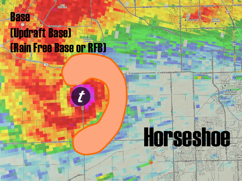
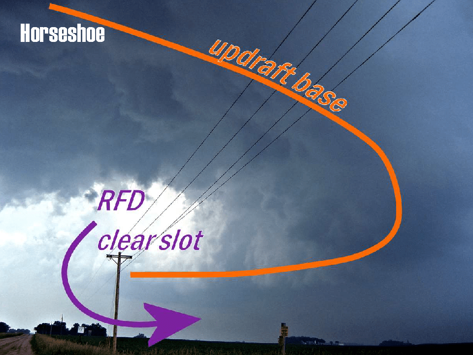
During a severe weather seminar in DuPage County, Ill. March 14, storm chaser and amateur meteorologist Skip Talbot pointed out that a horseshoe shape in a supercell thunderstorm’s updraft base is often visible before the storm forms a tornado (see figures one and two). Talbot said that this feature is a more reliable indicator of a potential tornado than is the formation of a wall cloud, which does not always happen before a tornado forms.
Figure 1. Horseshoe-shaped updraft base drawn on example radar image of a supercell thunderstorm. The “T” in a circle represents the location of a tornado. Image from presentation by Skip Talbot.
Figure 2. Photo of actual supercell thunderstorm with horseshoe-shaped updraft base indicated by orange line. Image from presentation by Skip Talbot.
Talbot’s presentation was one of several during the annual, day-long Severe Weather Seminar hosted in a western suburb of Chicago by the DuPage County Office of Homeland Security and Emergency Management.
Talbot’s presentation was titled, “Anticipating Tornadoes in Visual Clues,” and focused primarily on tornado-producing supercell thunderstorms. Fortunately, we don’t often see supercells in northern Indiana but all spotters need to know what to look for when those huge storms do arrive.
How big is a supercell?
Speaking of huge, Talbot cleverly superimposed a radar base-reflectivity image of a Plains supercell over a map of the Chicago area. This provided a clear idea of the scale of such storms (see Figure 3).
Figure 3. Simulation of a supercell thunderstorm radar image over map of Chicagoland. From presentation by Skip Talbot.
Tornado red flags
Talbot also provided a valuable list of “tornado red flags:”
Rain moving rapidly from left to right (as viewed from beyond the right side a supercell)
A sudden surge of wind flowing into the supercell
A sudden barrage of positive cloud-to-ground lightning.
While none of the above meet the SKYWARN storm spotter reporting criteria, they can help spotters remain alert to the strong possibility that a storm is about to produce something reportable!
Storm spotting squall lines (QLCS’)
Meteorologist Ben Deubelbeiss of the Chicago National Weather Service (NWS) office did a presentation that focused on “squall line” thunderstorms, to which meteorologists refer as quasi-linear convective systems (QLCS’). These types of storms are quite common here in northern Indiana, especially during the summer.
A QLCS is a line of thunderstorms that can extend hundreds of miles and persist for hours. It typically produces straight-line wind damage. Shelf clouds form along the leading edges of many QLCS’. Deubelbeiss pointed out that the bottoms of shelf clouds often contain a great deal of turbulence that results in many false reports of funnel clouds (See Figure 4). As trained storm spotters, we must guard against getting fooled by that turbulence.
Figure 4. No funnel cloud or wall cloud, just turbulence that often forms on the bottom of shelf clouds, resulting in false reports to the NWS. Photo from presentation by Ben Deubelbeiss, NWS Chicago.
Deubelbeiss also offered some important comparisons between QLCS’ and supercell thunderstorms. One relates to where the action is. In a supercell, our attention is at the right, rear portion of the storm, where tornado formation is most likely. But with a QLCS, “worst is first” as Deubelbeiss put it. The heaviest wind, occasional weak, short-lived “spin up” tornadoes and damage occur along the leading edge of a QLCS, followed by heavy rain.
Deubelbeiss also made an important point about spotter location. We’ve long been told that the best place to view supercell thunderstorms is where the storm’s heavy rain and hail are to our right and updraft is to our left (typically southeast of the storm). But where should we be when a QLCS approaches? Deubelbeiss strongly advises taking shelter in a building before the leading edge arrives, putting as many walls as possible between us and the outdoors. He reminded spotters that QLCS’ can have storm motion of more than 60 mph. He suggested waiting until the wind dies down to look outside for wind damage to report.
Technology for storm spotters
College of DuPage meteorology professor Dr. Victor Gensini provided an informative presentation, “Technology and Software for Spotter and Emergency Personnel.”
Among his recommendations was the GRLevel3 radar software available for PCs for a one-time fee of $79.95. The latest version is available for download at www.grlevelx.com/grlevel3_2/. GRLevel3 displays live and archive NEXRAD Level III data. It displays high resolution base products, dual polarization products, and derived products along with local storm reports, severe weather warnings, the positions of spotters who are registered with SpotterNetwork.org and other data.
For mobile devices, such as smartphones and tablets, Gensini recommended Radarscope (for iOS and Android) and PYKL3 (for Android only). You can find information about Radarscope at www.radarscope.tv and PYKL3 at www.pykl3radar.com. Like GRLevel3, both products integrate with SpotterNetwork.org.
Another valuable resource for spotters – especially the serious “weather geeks” among us – is a Web page maintained by the College of DuPage meteorology department (weather.cod.edu). The “Weather Analysis Tools” menu of that page offers a wide range of nationwide data, including surface maps, upper air maps, upper air soundings, satellite and radar data, numerical model data, etc.
Late season start
Finally, a note about complacency. The severe weather season nationwide got off to a late start this year, without a tornado reported anywhere in the country until March 25. Meteorologist Greg Carbin of the NWS Storm Prediction Center advised the spotters at the DuPage County seminar that climatologically speaking, severe weather someplace in the continental United States is likely to increase through the month of April. Remember also that in the 37-county area served by the northern Indiana NWS office, tornadoes are nearly twice as likely in April as in March, 1.8 times as likely in May as in April, and 1.7 times as likely in June (our peak tornado month) as in May.
Similarly, in the northern Indiana NWS area, severe thunderstorm winds (58 mph or stronger) are nearly 2.5 times as likely in April as in March, three times as likely in May as in April and nearly twice as likely in June (also our peak severe thunderstorm month) as in May.
So, don’t let the late start to the severe weather season fool you. As we get closer June, it becomes much more likely that our area will see severe weather and SKYWARN spotter activation. Be ready!
“There are millions of people across this country putting their lives on the line by listening for a sound they can’t hear.”
That’s my favorite line from a 2015 blog post by weather journalist Dennis Mersereau on now defunct “The Vane” blog.
Mersereau makes a strong case for a difficult change in mindset: relying on warning technology that’s more modern and reliable than the ubiquitous outdoor warning siren.
I’ve written about this topic myself. I’ve seen (as I imagine Mersereau has) more than one post-tornado report from the National Weather Service (NWS) that indicated victims failed to seek shelter after the NWS issued a warning, because they didn’t hear sirens. This has been true even for people who knew about the warning because they heard it on TV, saw it on Twitter, etc.
The main thesis of Mersereau’s post is absolutely correct: Communities will save a lot more lives spending money on free NOAA Weather Radio receivers for citizens than in upgrading or installing outdoor warning sirens.
But despite that facts that Mersereau presents, the average citizen doesn’t see it that way. You see, we have relied on outdoor warning sirens for so long (ever since the post-WWII re-purposing of air raid sirens — and that’s a long time) that they’ve become a strong tradition. I’d argue they’ve become an almost inextricable part of our culture.
As a case in point, (as I pointed out in my 2014 post linked above), I invite you to watch an Indianapolis Colts football game, where the stadium public address system often plays a warning siren sound effect. Why? Not because a storm is on the way, but because Colts staff members know that an emotional response to that sound is ingrained in fans.
The fact that the Colts use that sound effect in that way is evidence that outdoor warning sirens have become a part of our collective psyche. That’s hard to fight.
More evidence comes from the vehement arguments that siren-lovers have posted in comments beneath Mersereau’s blog post. As Mersereau put it in a tweet to me, “People believe in their sirens like a religion.”
That, my friends, is the real problem.
It will take a lot of public education (like Mersereau’s blog post) over a significant period of time to change that.
In the meantime, citizens will continue to expect their elected officials to spend money on an outdated, ineffective warning technology.